
Size of this PNG preview of this SVG file:
800 × 544 pixels. Other resolutions:
320 × 218 pixels |
640 × 435 pixels |
1,024 × 696 pixels |
1,280 × 870 pixels |
2,560 × 1,741 pixels |
1,000 × 680 pixels.
Original file (SVG file, nominally 1,000 × 680 pixels, file size: 179 KB)
| This is a file from the
Wikimedia Commons. Information from its
description page there is shown below. Commons is a freely licensed media file repository. You can help. |
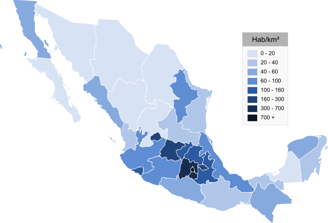
| Description | Map of Mexico, Mapa de Mexico, se muestra la densidad de población | ||
| Date | (UTC) | ||
| Source | |||
| Author |
|
| This is a
retouched picture, which means that it has been digitally altered from its original version. Modifications: svg. The original can be viewed here:
Mexico estados densidad.png:
|
I, the copyright holder of this work, hereby publish it under the following licenses:

|
Permission is granted to copy, distribute and/or modify this document under the terms of the GNU Free Documentation License, Version 1.2 or any later version published by the Free Software Foundation; with no Invariant Sections, no Front-Cover Texts, and no Back-Cover Texts. A copy of the license is included in the section entitled GNU Free Documentation License. |
| This file is licensed under the Creative Commons Attribution-Share Alike 3.0 Unported license. | ||
| ||
| This licensing tag was added to this file as part of the GFDL licensing update. |
| I, the copyright holder of this work, release this work into the
public domain. This applies worldwide. In some countries this may not be legally possible; if so: I grant anyone the right to use this work for any purpose, without any conditions, unless such conditions are required by law. |
You may select the license of your choice.
Original upload log
This image is a derivative work of the following images:
-
File:Mexico_estados_densidad.png licensed with GFDL, PD-self
- 2006-07-28T05:34:18Z Ek Balam 1000x682 (36070 Bytes) {{Information |Description= Map of Mexico, Mapa de Mexico, se muestra la densidad de población |Source= http://commons.wikimedia.org/wiki/Image:Mexico_states_blank.png |Date= 28 07 2006 |Author= Mario Fuente Cid, from a map
Uploaded with derivativeFX
File history
Click on a date/time to view the file as it appeared at that time.
| Date/Time | Thumbnail | Dimensions | User | Comment | |
|---|---|---|---|---|---|
| current | 23:34, 21 May 2009 |
| 1,000 × 680 (179 KB) | Addicted04 | trazo |
| 23:32, 21 May 2009 |
 | 1,000 × 680 (130 KB) | Addicted04 | {{Information |Description=Map of Mexico, Mapa de Mexico, se muestra la densidad de población |Source=* File:Mexico_estados_densidad.png |Date=2009-05-22 00:31 (UTC) |Author=* File:Mexico_estados_densidad.png: Mario Fuente Cid, from a map by Ja |
File usage
The following pages on the English Wikipedia use this file (pages on other projects are not listed):
Global file usage
The following other wikis use this file:
- Usage on af.wikipedia.org
- Usage on ar.wikipedia.org
- Usage on arz.wikipedia.org
- Usage on bg.wikipedia.org
- Usage on ca.wikipedia.org
- Usage on cs.wikipedia.org
- Usage on es.wikipedia.org
- Usage on hr.wikipedia.org
- Usage on ia.wikipedia.org
- Usage on is.wikipedia.org
- Usage on la.wikipedia.org
- Usage on lt.wikipedia.org
- Usage on pl.wikipedia.org
- Usage on pt.wikipedia.org
- Usage on sc.wikipedia.org
- Usage on sk.wikipedia.org
- Usage on uk.wikipedia.org
- Usage on ur.wikipedia.org
- Usage on www.wikidata.org