Size of this preview:
590 × 599 pixels. Other resolutions:
236 × 240 pixels |
473 × 480 pixels |
756 × 768 pixels |
1,008 × 1,024 pixels |
2,017 × 2,048 pixels |
4,886 × 4,962 pixels.
Original file (4,886 × 4,962 pixels, file size: 1.41 MB, MIME type: image/png)
| This is a file from the
Wikimedia Commons. Information from its
description page there is shown below. Commons is a freely licensed media file repository. You can help. |
.png)
Summary
| Description |
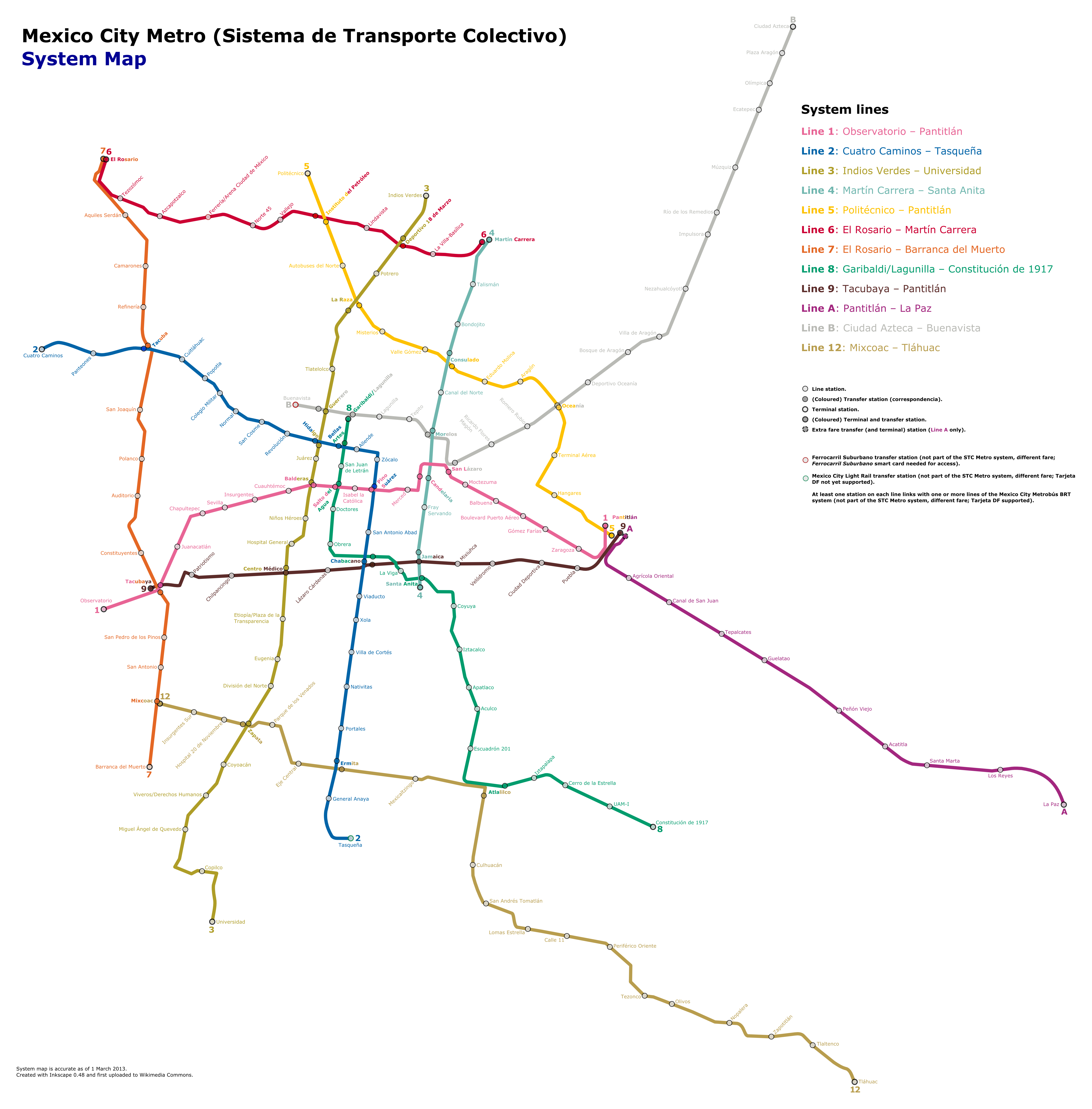
English: Mexico City Metro (Sistema de Transporte Colectivo) System Map. Based on actual system routes according to STC. Locations are accurate. All twelve lines of the system have been included, and station names are accurate as of 1 March 2013. English captions version.
Station names and any logos are property of Sistema de Transporte Colectivo. No copyright infringement intended. Español: Mapa del sistema de Metro de la Ciudad de México (Sistema de Transporte Colectivo). Basado en los recorridos de las rutas reales de acuerdo al STC. Las ubicaciones son exactas. Se incluyen las doce líneas del sistema, y los nombres de las estaciones son correctos al 1 de marzo de 2013. Versión con leyendas en inglés.
Los nombres de las estaciones y la iconografía son propiedad del Sistema de Transporte Colectivo. No se pretende la violación de los derechos de autor. |
| Date | |
| Source | Own work |
| Author | Fluence |
Licensing
I, the copyright holder of this work, hereby publish it under the following license:
This file is licensed under the
Creative Commons
Attribution-Share Alike 3.0 Unported license.
- You are free:
- to share – to copy, distribute and transmit the work
- to remix – to adapt the work
- Under the following conditions:
- attribution – You must give appropriate credit, provide a link to the license, and indicate if changes were made. You may do so in any reasonable manner, but not in any way that suggests the licensor endorses you or your use.
- share alike – If you remix, transform, or build upon the material, you must distribute your contributions under the same or compatible license as the original.
File history
Click on a date/time to view the file as it appeared at that time.
| Date/Time | Thumbnail | Dimensions | User | Comment | |
|---|---|---|---|---|---|
| current | 02:17, 24 September 2016 |
| 4,886 × 4,962 (1.41 MB) | Fluence | Reverted to version as of 06:20, 1 March 2013 (UTC) |
| 17:31, 29 September 2014 |
 | 4,886 × 4,962 (1.42 MB) | Fluence | Line 12 partially suspended in accordance with the information of the article, and usable if anyone unaware of this is using the system. To be reverted when the system is fully operational again. | |
| 06:20, 1 March 2013 |
 | 4,886 × 4,962 (1.41 MB) | Fluence | Added margins | |
| 04:55, 1 March 2013 |
 | 4,884 × 4,962 (1.45 MB) | Fluence | Size reduced. | |
| 04:52, 1 March 2013 |
 | 7,182 × 7,297 (2.2 MB) | Fluence | Size reduced. | |
| 04:49, 1 March 2013 |
 | 8,619 × 8,756 (2.8 MB) | Fluence | User created page with UploadWizard |
File usage
The following pages on the English Wikipedia use this file (pages on other projects are not listed):
Global file usage
The following other wikis use this file:
- Usage on ar.wikipedia.org
- Usage on fa.wikipedia.org
- Usage on he.wikipedia.org
- Usage on hu.wikipedia.org
- Usage on id.wikipedia.org
- Usage on ja.wikipedia.org
- Usage on ms.wikipedia.org
- Usage on ru.wikivoyage.org
- Usage on th.wikipedia.org
- Usage on tr.wikipedia.org
- Usage on uz.wikipedia.org
- Usage on vi.wikipedia.org
- Usage on www.wikidata.org
.png)