No higher resolution available.
Metrolinamap.png (350 × 137 pixels, file size: 42 KB, MIME type: image/png)
| This is a file from the
Wikimedia Commons. Information from its
description page there is shown below. Commons is a freely licensed media file repository. You can help. |
Summary
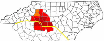
| Description |
CSA and MSA of the Metrolina area. Adapted from Wikipedia's NC county maps by Seth Ilys. |
| Date | 25 April 2006 (original upload date) |
| Source | No machine-readable source provided. Own work assumed (based on copyright claims). |
| Author | No machine-readable author provided. Gooday.1~commonswiki assumed (based on copyright claims). |
Licensing
| I, the copyright holder of this work, release this work into the
public domain. This applies worldwide. In some countries this may not be legally possible; if so: I grant anyone the right to use this work for any purpose, without any conditions, unless such conditions are required by law. |
File history
Click on a date/time to view the file as it appeared at that time.
| Date/Time | Thumbnail | Dimensions | User | Comment | |
|---|---|---|---|---|---|
| current | 04:21, 29 December 2006 |
| 350 × 137 (42 KB) | Gooday.1~commonswiki | CSA and MSA and Charlotte USA of the Metrolina area. Adapted from Wikipedia's NC county maps by Seth Ilys. |
| 04:12, 22 October 2006 |
| 350 × 137 (47 KB) | Gooday.1~commonswiki | More asthetically pleasing map of the Charlotte metro area (Metrolina). Red is the most commonly accepted Metrolina area. Orange shows areas sometimes included. MSA and CSA have been left out due to their conflicting representation and overlying other reg | |
| 03:50, 25 April 2006 |
| 300 × 117 (34 KB) | Gooday.1~commonswiki | CSA and MSA of the Metrolina area. Adapted from Wikipedia's NC county maps by Seth Ilys. |
File usage
The following pages on the English Wikipedia use this file (pages on other projects are not listed):
- Charlotte metropolitan area
- User talk:Aegreen
- User talk:Baseball Bugs/Archive002
- User talk:Blackcats
- User talk:BobbyAFC
- User talk:Fife Club
- User talk:Grinning Fool
- User talk:Jdb1972
- User talk:SQFreak
- User talk:Shizane
- User talk:Toa Nidhiki05/Archive 5
- User talk:Washuotaku/Archive 2012
- User talk:Wikipedianinthehouse
- Wikipedia:WikiProject Charlotte
- Wikipedia:WikiProject Charlotte/welcome
Global file usage
The following other wikis use this file:
- Usage on de.wikipedia.org
- Usage on es.wikipedia.org
- Usage on fr.wikipedia.org
- Usage on it.wikivoyage.org
- Usage on pl.wikipedia.org
- Usage on ur.wikipedia.org
- Usage on www.wikidata.org