
Size of this PNG preview of this SVG file:
800 × 167 pixels. Other resolutions:
320 × 67 pixels |
640 × 133 pixels |
1,024 × 213 pixels |
1,280 × 266 pixels |
2,560 × 533 pixels |
1,936 × 403 pixels.
Original file (SVG file, nominally 1,936 × 403 pixels, file size: 407 KB)
| This is a file from the
Wikimedia Commons. Information from its
description page there is shown below. Commons is a freely licensed media file repository. You can help. |
.svg)
Summary
| Description |
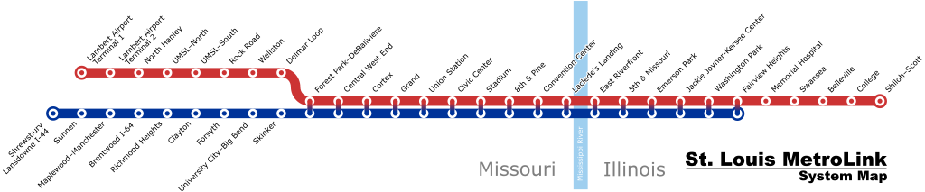
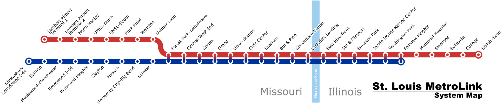
English: A schematic map of the the St. Louis MetroLink system as of August 2018 |
| Date | (latest version) |
| Source | Own work |
| Author | Millbrooky |
| Other versions |
 |
Licensing
I, the copyright holder of this work, hereby publish it under the following license:
This file is licensed under the
Creative Commons
Attribution-Share Alike 3.0 Unported license.
- You are free:
- to share – to copy, distribute and transmit the work
- to remix – to adapt the work
- Under the following conditions:
- attribution – You must give appropriate credit, provide a link to the license, and indicate if changes were made. You may do so in any reasonable manner, but not in any way that suggests the licensor endorses you or your use.
- share alike – If you remix, transform, or build upon the material, you must distribute your contributions under the same or compatible license as the original.
File history
Click on a date/time to view the file as it appeared at that time.
| Date/Time | Thumbnail | Dimensions | User | Comment | |
|---|---|---|---|---|---|
| current | 14:29, 2 April 2019 |
| 1,936 × 403 (407 KB) | Dream out loud | extended Blue Line to Fairview Heights |
| 12:23, 21 February 2019 |
| 1,936 × 403 (392 KB) | Dream out loud | fixed station names, changed appearance of Red/Blue shared stations | |
| 19:39, 11 August 2018 |
| 1,925 × 380 (473 KB) | Pi.1415926535 | update for Cortex station opening | |
| 23:57, 9 March 2015 |
| 1,920 × 460 (390 KB) | Dream out loud | updated Laclede's Landing station name | |
| 21:21, 1 February 2015 |
| 1,920 × 460 (385 KB) | Dream out loud | ||
| 21:20, 31 October 2008 |
| 1,920 × 460 (484 KB) | Millbrooky | one last revision to make text slightly larger | |
| 17:57, 29 October 2008 |
| 1,885 × 400 (492 KB) | Millbrooky | {{Information |Description= |Source= |Date= |Author= |Permission= |other_versions= }} | |
| 15:53, 28 October 2008 |
| 1,885 × 400 (72 KB) | Millbrooky | {{Information |Description={{en|1=A schematic map of the the St. Louis MetroLink system as of October 27, 2008.}} |Source=Own work by uploader |Author= Millbrooky |Date=2008 |Permission= |other_versions=MetroLink map.svg }} <!--{{Image |
File usage
The following pages on the English Wikipedia use this file (pages on other projects are not listed):
Global file usage
The following other wikis use this file:
- Usage on cy.wikipedia.org
- Usage on de.wikipedia.org
- Usage on fr.wikipedia.org
- Usage on he.wikivoyage.org
- Usage on ru.wikipedia.org
- Usage on uk.wikipedia.org
- Usage on www.wikidata.org
- Usage on zh.wikipedia.org
.svg)