
Original file (3,773 × 2,832 pixels, file size: 5.09 MB, MIME type: image/jpeg)
| This is a file from the
Wikimedia Commons. Information from its
description page there is shown below. Commons is a freely licensed media file repository. You can help. |
Summary
| Description |
English: W. H.L. McCOURTIE
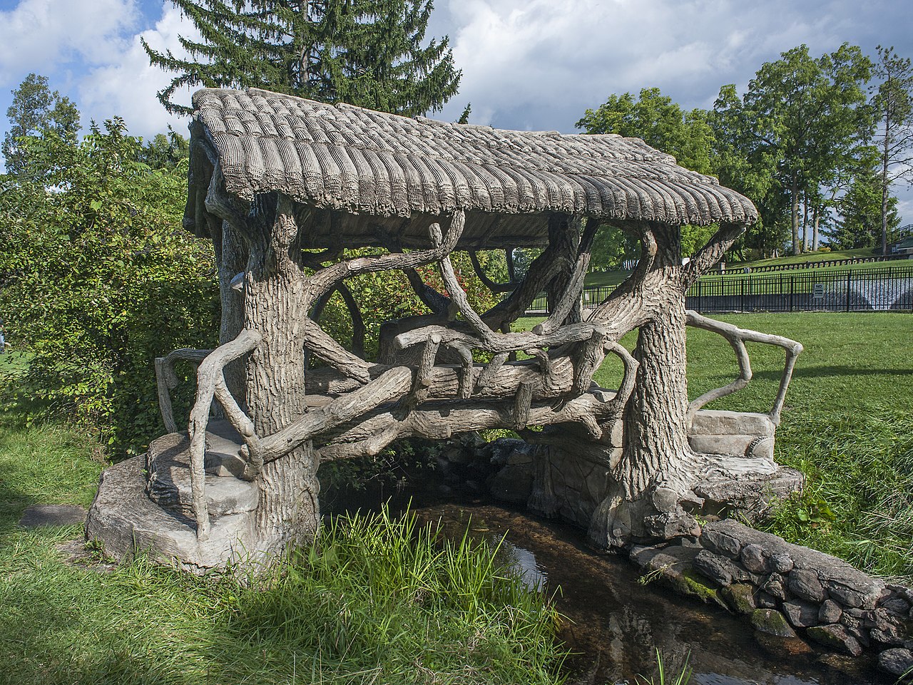
Somerset Center native W. H. L. McCourtie (1872-1933) was introduced to the cement industry by W. F. Cowham of Jackson in 1897. McCourtle soon went to Dallas. Texas. where he made a fortune speculatlng in oil and establlshed the Trinity Portland Cement Company. During the 192Os McCourtle returned to Somerset Center. In 1924 he acquired his famlly's home and turned it into a community showplace. McCourtle sought to create a model town, giving free white paint to any homeowner who needed it. He also hosted the communlty's annual homecomlng celebrations. Thousands of people came to "Aiden Lair" to witness stunt flyers and enjoy baseball, local musicians, dancing and unlimited refreshments. At the helght of the Great Depression. McCourtle offered his estate as a place "Where Friends Meet Frlends and Part More Frlendly." W. R L. McCOURTIE ESTATE The W. H. L. McCourtie Estate may contain the country's largest collection of el trabeio rustico. the Mexican folk tradition of sculpting concrete to look like wood. Around 1930, most likely inspired by work he had seen in Texas, cement tycoon W. H. L. McCourtie hired Itinerant Mexican artisans George Cardoso and Ralph Corona to construct seventeen bridges on his property. The artisans formed the bridges with steel rods and then band sculpted wet concrete to resemble planed lumber, rough logs, thatch and rope. Different species of trees can be identified. Two concrete trees that stand on the property continue to serve as chimneys for the underground rathskeller and garage. The McCourtie estate is listed in the National Register of Historic Places.
|
||
| Date | |||
| Source | Own work | ||
| Author | Aaron headly |
| Camera location | | View this and other nearby images on: OpenStreetMap |
|
|---|
Licensing
- You are free:
- to share – to copy, distribute and transmit the work
- to remix – to adapt the work
- Under the following conditions:
- attribution – You must give appropriate credit, provide a link to the license, and indicate if changes were made. You may do so in any reasonable manner, but not in any way that suggests the licensor endorses you or your use.
- share alike – If you remix, transform, or build upon the material, you must distribute your contributions under the same or compatible license as the original.

|
This image was uploaded as part of
Wiki Loves Monuments 2019.
|
 |
File history
Click on a date/time to view the file as it appeared at that time.
| Date/Time | Thumbnail | Dimensions | User | Comment | |
|---|---|---|---|---|---|
| current | 16:41, 7 September 2019 |
| 3,773 × 2,832 (5.09 MB) | Aaron headly | User created page with UploadWizard |