
Size of this preview:
800 × 450 pixels. Other resolutions:
320 × 180 pixels |
640 × 360 pixels |
1,024 × 576 pixels |
1,280 × 720 pixels |
2,048 × 1,152 pixels.
Original file (2,048 × 1,152 pixels, file size: 2.86 MB, MIME type: image/png)
| This is a file from the
Wikimedia Commons. Information from its
description page there is shown below. Commons is a freely licensed media file repository. You can help. |
Summary
| Description |
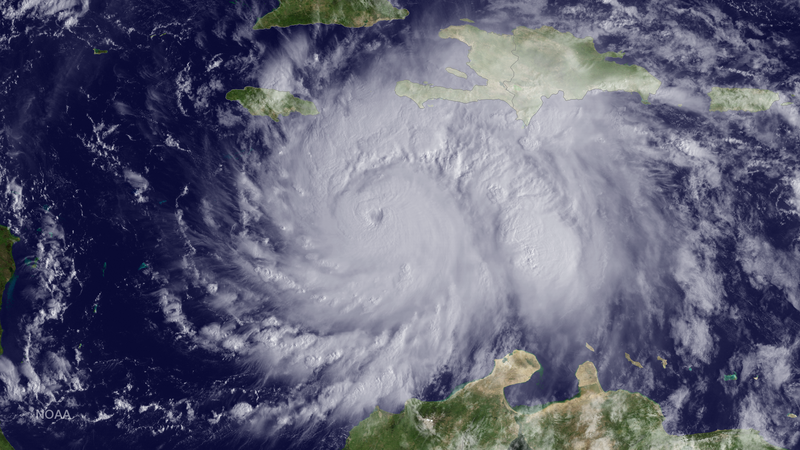
English: The GOES East satellite captured this image of Hurricane Matthew, currently located about 220 miles southeast of Kingston, Jamaica, at 1315 UTC on October 3, 2016. |
| Date | |
| Source | https://www.nnvl.noaa.gov/MediaDetail2.php?MediaID=1935&MediaTypeID=1 |
| Author | NOAA |
Licensing
This image is in the
public domain because it contains materials that originally came from the U.S.
National Oceanic and Atmospheric Administration, taken or made as part of an employee's official duties.
|
File history
Click on a date/time to view the file as it appeared at that time.
| Date/Time | Thumbnail | Dimensions | User | Comment | |
|---|---|---|---|---|---|
| current | 08:55, 24 March 2018 |
| 2,048 × 1,152 (2.86 MB) | A1Cafel | User created page with UploadWizard |
File usage
The following pages on the English Wikipedia use this file (pages on other projects are not listed):
Global file usage
The following other wikis use this file:
- Usage on de.wikipedia.org
- Usage on kn.wikipedia.org
- Usage on mk.wikipedia.org
- Usage on ru.wikipedia.org
- Usage on uk.wikipedia.org