
Size of this PNG preview of this SVG file:
650 × 550 pixels. Other resolutions:
284 × 240 pixels |
567 × 480 pixels |
908 × 768 pixels |
1,210 × 1,024 pixels |
2,420 × 2,048 pixels.
Original file (SVG file, nominally 650 × 550 pixels, file size: 403 KB)
| This is a file from the
Wikimedia Commons. Information from its
description page there is shown below. Commons is a freely licensed media file repository. You can help. |
Summary
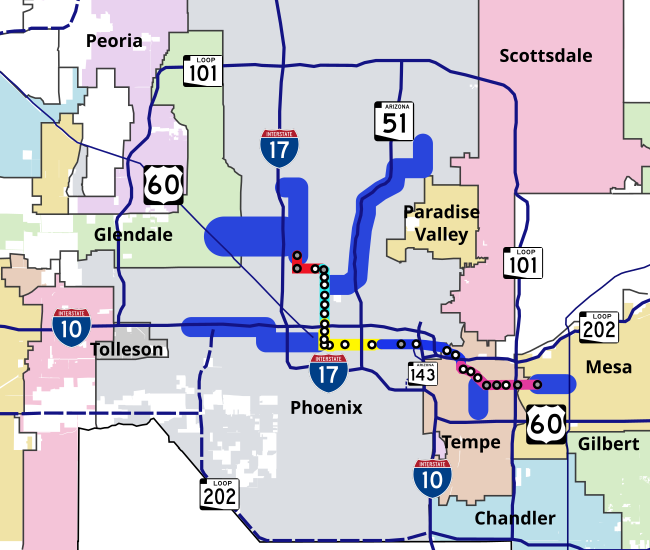
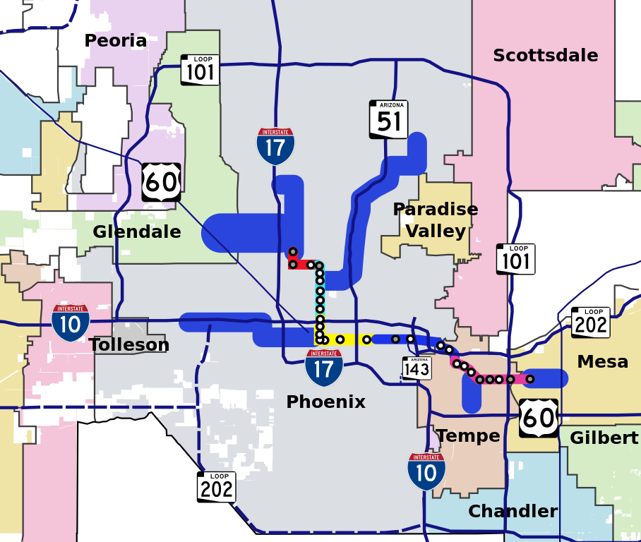
| Description | Geographical map of METRO Light Rail system of Phoenix, Arizona, showing the starter route and future expansion corridors. Also shown are city borders and highways in the vicinity of the light rail system. Stops are shown as white circles and park-and-ride stops are shown as gray circles. |
| Date | |
| Source | My own work, based off of maps from Valley Metro website ( Light Rail Maps Page) |
| Author | en:User:Ixnayonthetimmay |
| Permission ( Reusing this file) |
Public Domain |
Licensing
| I, the copyright holder of this work, release this work into the
public domain. This applies worldwide. In some countries this may not be legally possible; if so: I grant anyone the right to use this work for any purpose, without any conditions, unless such conditions are required by law. |
File history
Click on a date/time to view the file as it appeared at that time.
| Date/Time | Thumbnail | Dimensions | User | Comment | |
|---|---|---|---|---|---|
| current | 03:31, 24 September 2007 |
| 650 × 550 (403 KB) | Ixnayonthetimmay | |
| 03:22, 24 September 2007 |
 | 650 × 550 (404 KB) | Ixnayonthetimmay | ||
| 03:19, 24 September 2007 |
 | 650 × 550 (403 KB) | Ixnayonthetimmay | ||
| 03:15, 24 September 2007 |
 | 650 × 550 (392 KB) | Ixnayonthetimmay | {{Information |Description=Geographical map of METRO Light Rail system of Phoenix, Arizona, showing the starter route and future expansion corridors. Also shown are city borders a |
File usage
The following pages on the English Wikipedia use this file (pages on other projects are not listed):
Global file usage
The following other wikis use this file:
- Usage on ja.wikipedia.org
- Usage on pl.wikipedia.org
- Usage on ru.wikipedia.org
- Usage on zh.wikipedia.org