
Size of this PNG preview of this SVG file:
432 × 600 pixels. Other resolutions:
173 × 240 pixels |
345 × 480 pixels |
553 × 768 pixels |
737 × 1,024 pixels |
1,474 × 2,048 pixels |
787 × 1,093 pixels.
Original file (SVG file, nominally 787 × 1,093 pixels, file size: 19.74 MB)
| This is a file from the
Wikimedia Commons. Information from its
description page there is shown below. Commons is a freely licensed media file repository. You can help. |
Summary
| Description |
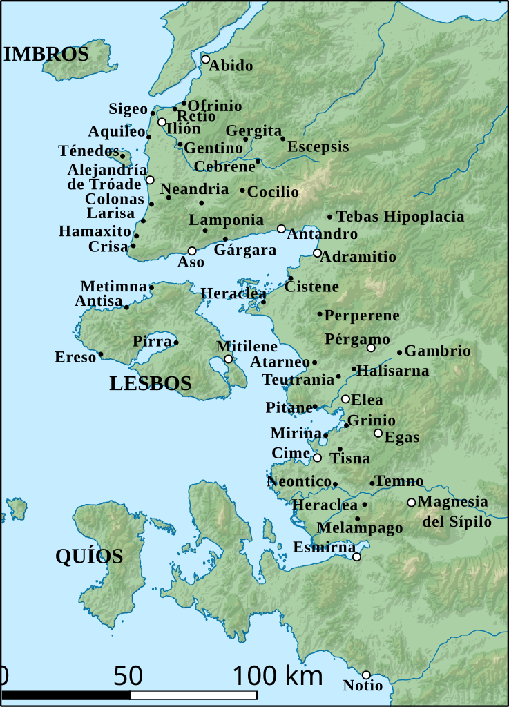
Español: Mapa con algunas de las antiguas ciudades griegas de Eólida. |
| Date | |
| Source |
MapaTopográficoDeAsiaMenor-Eólida.png MapaTopográficoDeAsiaMenor.svg |
| Author |
Licensing
This file is licensed under the
Creative Commons
Attribution-Share Alike 4.0 International license.
- You are free:
- to share – to copy, distribute and transmit the work
- to remix – to adapt the work
- Under the following conditions:
- attribution – You must give appropriate credit, provide a link to the license, and indicate if changes were made. You may do so in any reasonable manner, but not in any way that suggests the licensor endorses you or your use.
- share alike – If you remix, transform, or build upon the material, you must distribute your contributions under the same or compatible license as the original.
File history
Click on a date/time to view the file as it appeared at that time.
| Date/Time | Thumbnail | Dimensions | User | Comment | |
|---|---|---|---|---|---|
| current | 00:18, 5 December 2019 |
| 787 × 1,093 (19.74 MB) | Rowanwindwhistler | New version using SRTM (relief) & WBDII (river & coast) data. Projection EPSG 2181. |
| 10:36, 30 July 2017 |
 | 1,224 × 1,403 (2.3 MB) | Rowanwindwhistler | Some errors corrected (Magnesia del Sípilo, Metimna, Ereso, Antisa, Antandro). | |
| 07:34, 13 July 2017 |
 | 1,224 × 1,403 (2.3 MB) | Rowanwindwhistler | User created page with UploadWizard |
File usage
The following pages on the English Wikipedia use this file (pages on other projects are not listed):
- Achaion Limen
- Aegiroessa
- Astyra (Aeolis)
- Astyra (near Pergamon)
- Astyria
- Atarneus sub Pitanem
- Attea
- Autokane
- Boione
- Chalcis (Aeolis)
- Chryse (Aeolis)
- Cilla (city)
- Cisthene (Mysia)
- Coryphas
- Dascylium (Aeolis)
- Gambrium
- Heraclea (Aeolis)
- Iolla
- Kyllene (Aeolis)
- Malene
- Melampagos
- Nasos
- Naulochon
- Neonteichos
- Palaegambrium
- Perperene
- Pordoselene
- Temnos
- Tisna
- Template:AncientAeolis-geo-stub
Global file usage
The following other wikis use this file:
- Usage on es.wikipedia.org
- Elea (Eólida)
- Eólida
- Alejandría de Tróade
- Magnesia del Sípilo
- Tebas Hipoplacia
- Pítane
- Cebrene
- Antandro
- Escepsis
- Notio
- Mirina (Misia)
- Teutrania
- Gergita
- Larisa (Tróade)
- Hamaxito
- Lamponia
- Neandria
- Cocilio
- Gárgara (ciudad)
- Neontico
- Cistene
- Perperene
- Heraclea (Perea lesbia)
- Gambrio
- Halisarna
- Gentino
- Tisna
- Melampagos
- Heraclea (junto a Melampagos)
- Adramitio
- Usage on tr.wikipedia.org