
Size of this preview:
800 × 458 pixels. Other resolutions:
320 × 183 pixels |
640 × 366 pixels |
1,024 × 586 pixels |
1,280 × 732 pixels |
2,560 × 1,465 pixels |
11,430 × 6,540 pixels.
Original file (11,430 × 6,540 pixels, file size: 48.27 MB, MIME type: image/jpeg)
| This is a file from the
Wikimedia Commons. Information from its
description page there is shown below. Commons is a freely licensed media file repository. You can help. |
Summary
| Description |
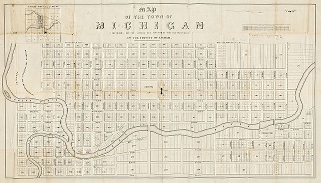
English: Map of the town of Michigan : (comprising section sixteen and portions of nine and twenty one) in the county of Ingham / surveyed by T. McCracken.
Originally published: N[ew] Y[ork] : Miller's Lith., [1847] An 1847 plat map of Lansing, Michigan, oriented with north to the right, with the name of the city given as "the town of Michigan," prior to the Michigan Legislature's establishment of the city's name as "Lansing" in 1848. Many of the street names are still in use. The area at the left (south) labeled "Reserved for hydraulic and manufacturing purposes" would later be the site of the Grand River Assembly and the Lansing Board of Water & Light's Otto E. Eckert Station. Scan of a map in the collection of the Michigan State University Map Library. MSU Libraries catalog record: http://catalog.lib.msu.edu/record=b4958646~S39a |
| Date | |
| Source | http://www.lib.msu.edu/branches/map/MiJPEGS/843-d-E-1847/ |
| Author | Surveyed by T. McCracken. Miller's Lith. |
Licensing
This media file is in the
public domain in the
United States. This applies to U.S. works where the copyright has expired, often because its first
publication occurred prior to January 1, 1929, and if not then due to lack of notice or renewal. See
this page for further explanation.
|
 | |
 |
This image might not be in the public domain outside of the United States; this especially applies in the countries and areas that do not apply the
rule of the shorter term for US works, such as Canada, Mainland China (not Hong Kong or Macao), Germany, Mexico, and Switzerland. The creator and year of publication are essential information and must be provided. See
Wikipedia:Public domain and
Wikipedia:Copyrights for more details.
|
File history
Click on a date/time to view the file as it appeared at that time.
| Date/Time | Thumbnail | Dimensions | User | Comment | |
|---|---|---|---|---|---|
| current | 20:37, 3 November 2016 |
| 11,430 × 6,540 (48.27 MB) | TimK MSI | cropped |
| 19:33, 3 November 2016 |
 | 12,415 × 8,166 (13.37 MB) | TimK MSI | {{Information |Description ={{en|1=Map of the town of Michigan : (comprising section sixteen and portions of nine and twenty one) in the county of Ingham / surveyed by T. McCracken. Originally published: N[ew] Y[ork] : Miller's Lith., [1847] An 18... |
File usage
The following pages on the English Wikipedia use this file (pages on other projects are not listed):