
Size of this PNG preview of this SVG file:
784 × 600 pixels. Other resolutions:
314 × 240 pixels |
628 × 480 pixels |
1,004 × 768 pixels |
1,280 × 979 pixels |
2,560 × 1,958 pixels |
1,204 × 921 pixels.
Original file (SVG file, nominally 1,204 × 921 pixels, file size: 529 KB)
| This is a file from the
Wikimedia Commons. Information from its
description page there is shown below. Commons is a freely licensed media file repository. You can help. |
|
| This is a featured picture, which means that members of the community have identified it as one of the finest images on the English Wikipedia, adding significantly to its accompanying article. If you have a different image of similar quality, be sure to upload it using the proper free license tag, add it to a relevant article, and nominate it. |
|
| This image was selected as picture of the day on the English Wikipedia for July 1, 2016. |
|
Summary
| Description |
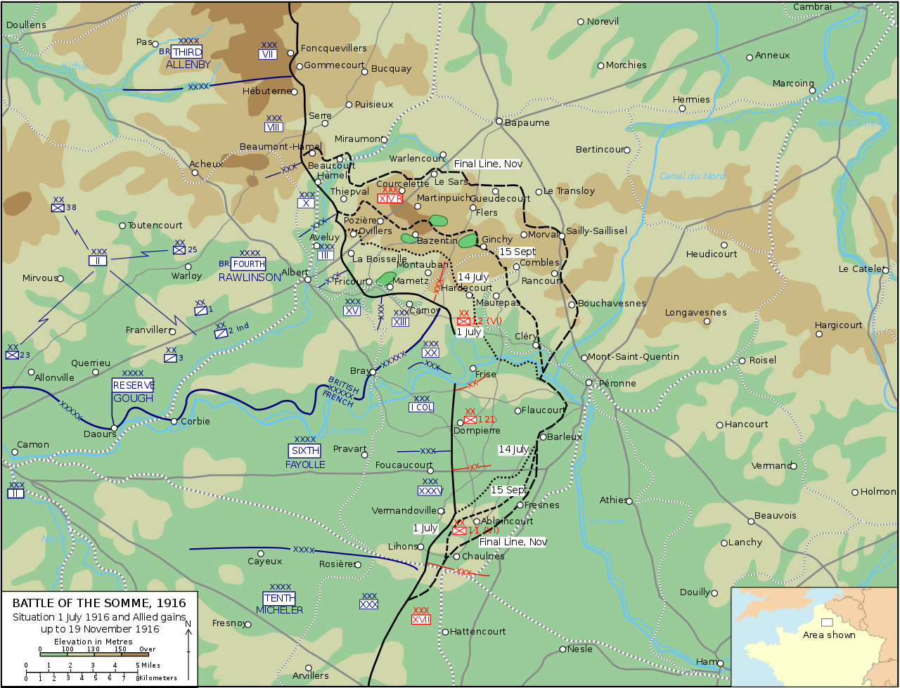
English: Map of the
Battle of the Somme, 1916. |
| Date | |
| Source | Own work |
| Author |
|
| SVG development |
Licensing
SVG version
I, the copyright holder of this work, hereby publish it under the following license:
This file is licensed under the
Creative Commons
Attribution-Share Alike 3.0 Unported license.
- You are free:
- to share – to copy, distribute and transmit the work
- to remix – to adapt the work
- Under the following conditions:
- attribution – You must give appropriate credit, provide a link to the license, and indicate if changes were made. You may do so in any reasonable manner, but not in any way that suggests the licensor endorses you or your use.
- share alike – If you remix, transform, or build upon the material, you must distribute your contributions under the same or compatible license as the original.
Underlying work
This file is a work of a
U.S. Army soldier or employee, taken or made as part of that person's official duties. As a
work of the
U.S. federal government, it is in the
public domain in the United States.
|
 |
Inset map
This file is licensed under the
Creative Commons
Attribution-Share Alike 2.5 Generic license.
Attribution: Giro720
- You are free:
- to share – to copy, distribute and transmit the work
- to remix – to adapt the work
- Under the following conditions:
- attribution – You must give appropriate credit, provide a link to the license, and indicate if changes were made. You may do so in any reasonable manner, but not in any way that suggests the licensor endorses you or your use.
- share alike – If you remix, transform, or build upon the material, you must distribute your contributions under the same or compatible license as the original.
File history
Click on a date/time to view the file as it appeared at that time.
| Date/Time | Thumbnail | Dimensions | User | Comment | |
|---|---|---|---|---|---|
| current | 15:17, 12 December 2016 |
| 1,204 × 921 (529 KB) | BjKa | Corrected spellings: Courcelette, Foucaucourt, Rosières, Péronne, Hébuterne, Flaucourt, Mont-Saint-Quentin Box around "RESERVE" widened Date fonts unified, southern "15 Sept" moved Label "Flers" moved slightly Péronne simplified and "place icon" ad... |
| 16:22, 5 July 2013 |
 | 1,204 × 921 (525 KB) | Grandiose | Inset map | |
| 20:37, 3 July 2013 |
 | 1,204 × 921 (311 KB) | Grandiose | Tweaks | |
| 20:32, 3 July 2013 |
 | 1,204 × 921 (311 KB) | Grandiose | Rm excess border | |
| 20:27, 3 July 2013 |
 | 1,242 × 961 (304 KB) | Grandiose | User created page with UploadWizard |
File usage
The following pages on the English Wikipedia use this file (pages on other projects are not listed):
- 188th Brigade (United Kingdom)
- 1916
- 38th (Welsh) Infantry Division
- 63rd (Royal Naval) Division
- Attack on the Gommecourt Salient
- Attacks on High Wood
- Attacks on the Butte de Warlencourt
- Battle of Albert (1916)
- Battle of Bazentin Ridge
- Battle of Delville Wood
- Battle of Flers–Courcelette
- Battle of Ginchy
- Battle of Guillemont
- Battle of Le Transloy
- Battle of Morval
- Battle of Pozières
- Battle of Thiepval Ridge
- Battle of the Ancre
- Battle of the Ancre Heights
- Battle of the Somme
- Capture of Beaumont-Hamel
- Capture of Combles
- Capture of Contalmaison
- Capture of Eaucourt l'Abbaye
- Capture of Fricourt
- Capture of Gueudecourt
- Capture of La Boisselle
- Capture of Le Sars
- Capture of Lesbœufs
- Capture of Mametz
- Capture of Martinpuich
- Capture of Montauban
- Capture of Ovillers
- Capture of Regina Trench
- Capture of Stuff Redoubt
- Capture of Trônes Wood
- Delville Wood order of battle
- Fighting for Mouquet Farm
- First day on the Somme
- Hindenburg Line
- History of the British 8th Division during the First World War
- Leipzig Salient
- Lochnagar mine
- Operations on the Ancre, January–March 1917
- Order of battle for the Battle of the Somme
- Ovillers-la-Boisselle in World War I
- Reserve Army (United Kingdom)
- Worcestershire Rifles
- Y Sap mine
- Talk:Battle of the Somme/Archive 4
- User:Grandiose
- User:Grandiose/archive7
- User:Grandiose/articles
- User talk:Grandiose
- Wikipedia:Featured picture candidates/August-2013
- Wikipedia:Featured picture candidates/July-2013
- Wikipedia:Featured picture candidates/Map of the Battle of the Somme
- Wikipedia:Featured picture candidates/Map of the Battle of the Somme (2)
- Wikipedia:Featured pictures/Diagrams, drawings, and maps/Maps
- Wikipedia:Featured pictures thumbs/36
- Wikipedia:Main Page history/2016 July 1
- Wikipedia:Picture of the day/July 2016
- Wikipedia:Top 25 Report/June 26 to July 2, 2016
- Wikipedia:WikiProject Military history/News/July 2016/Op-ed
- Wikipedia:WikiProject Military history/News/September 2013/Articles
- Wikipedia:Wikipedia Signpost/2016-07-21/Traffic report
- Wikipedia:Wikipedia Signpost/Single/2016-07-21
- Wikipedia talk:WikiProject Military history/Archive 120
- Template:POTD/2016-07-01
- Portal:History/Featured picture
- Draft:Battle of the Somme casualties controversy
Global file usage
The following other wikis use this file:
- Usage on ar.wikipedia.org
- Usage on azb.wikipedia.org
- Usage on az.wikipedia.org
- Usage on be.wikipedia.org
- Usage on bg.wikipedia.org
- Usage on ca.wikipedia.org
- Usage on de.wikipedia.org
- Usage on et.wikipedia.org
- Usage on fa.wikipedia.org
- Usage on fr.wikipedia.org
- Usage on gd.wikipedia.org
- Usage on he.wikipedia.org
- Usage on hy.wikipedia.org
- Usage on lv.wikipedia.org
- Usage on ms.wikipedia.org
- Usage on ru.wikipedia.org
- Usage on th.wikipedia.org
- Usage on tt.wikipedia.org
- Usage on uk.wikipedia.org
- Usage on ur.wikipedia.org
- Usage on www.wikidata.org
View more global usage of this file.