
Size of this PNG preview of this SVG file:
672 × 600 pixels. Other resolutions:
269 × 240 pixels |
538 × 480 pixels |
861 × 768 pixels |
1,148 × 1,024 pixels |
2,295 × 2,048 pixels |
4,270 × 3,810 pixels.
Original file (SVG file, nominally 4,270 × 3,810 pixels, file size: 110 KB)
| This is a file from the
Wikimedia Commons. Information from its
description page there is shown below. Commons is a freely licensed media file repository. You can help. |
Summary
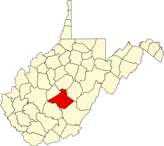
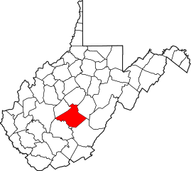
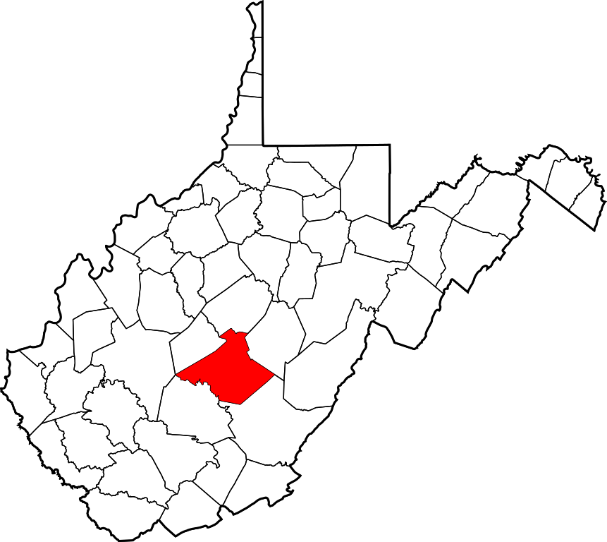
- Locator map showing Nicholas County in West Virginia.
- Credits
David Benbennick made this map.
For more information, see Commons:United States county locator maps.
| I, the copyright holder of this work, release this work into the
public domain. This applies worldwide. In some countries this may not be legally possible; if so: I grant anyone the right to use this work for any purpose, without any conditions, unless such conditions are required by law. |
File history
Click on a date/time to view the file as it appeared at that time.
| Date/Time | Thumbnail | Dimensions | User | Comment | |
|---|---|---|---|---|---|
| current | 18:12, 12 February 2006 |
| 4,270 × 3,810 (110 KB) | David Benbennick | {{subst:User:Dbenbenn/clm|county=Nicholas County|state=West Virginia|type=county}} |
File usage
The following pages on the English Wikipedia use this file (pages on other projects are not listed):
- Allingdale, West Virginia
- Bays, West Virginia
- Belva, West Virginia
- Bentree, West Virginia
- Birch River, West Virginia
- Bruce, West Virginia
- Calvin, West Virginia
- Cambria, West Virginia
- Canvas, West Virginia
- Carl, West Virginia
- Coe, West Virginia
- Cottle, West Virginia
- Craigsville, West Virginia
- Curtin, Nicholas County, West Virginia
- Dixie, Nicholas County, West Virginia
- Donald, West Virginia
- Drennen, West Virginia
- Enon, West Virginia
- Fenwick, West Virginia
- Gad, West Virginia
- Gilboa, West Virginia
- Green Valley, Nicholas County, West Virginia
- Holcomb, West Virginia
- Hominy Falls, West Virginia
- Hookersville, West Virginia
- Keslers Cross Lanes, West Virginia
- Kirkwood, West Virginia
- Leivasy, West Virginia
- List of counties in West Virginia
- Lockwood, West Virginia
- Morris, West Virginia
- Mount Lookout, West Virginia
- Mount Nebo, Nicholas County, West Virginia
- Muddlety, West Virginia
- Nallen, West Virginia
- National Register of Historic Places listings in Nicholas County, West Virginia
- Nettie, West Virginia
- New Hope, Nicholas County, West Virginia
- Nicholas County, West Virginia
- Odell Town, West Virginia
- Persinger, West Virginia
- Poe, West Virginia
- Pool, West Virginia
- Richwood, West Virginia
- Runa, West Virginia
- Saxman, West Virginia
- Snow Hill, Nicholas County, West Virginia
- Sparks, West Virginia
- Summersville, West Virginia
- Swiss, West Virginia
- Tioga, West Virginia
- Tolbert, West Virginia
- Vaughan, West Virginia
- Vinton, West Virginia
- Waggy, West Virginia
- Werth, West Virginia
- Woodbine, West Virginia
- Zela, West Virginia
- User:Nyttend/County templates/WV
- User:WVnativeson/sandbox14
- Template:Nicholas County, West Virginia
- Category:Populated places in Nicholas County, West Virginia
Global file usage
The following other wikis use this file:
- Usage on ar.wikipedia.org
- Usage on bg.wikipedia.org
- Usage on bpy.wikipedia.org
- Usage on cdo.wikipedia.org
- Usage on ceb.wikipedia.org
- Usage on ce.wikipedia.org
- Usage on cy.wikipedia.org
- Usage on de.wikipedia.org
- Usage on eo.wikipedia.org
- Usage on es.wikipedia.org
- Usage on et.wikipedia.org
- Usage on eu.wikipedia.org
- Usage on fa.wikipedia.org
- بلوا، ویرجینیای غربی
- برچ ریور، ویرجینیای غربی
- کرایگسویل، ویرجینیای غربی
- دیکسی، ویرجینیای غربی
- فنویک، ویرجینیای غربی
- نتی، ویرجینیای غربی
- ریکوود، ویرجینیای غربی
- سامرسویل، ویرجینیای غربی
- تیوگا، ویرجینیای غربی
- الینگدال، ویرجینیای غربی
- شهرستان نیکولاس، ویرجینیای غربی
- نیو هوپ، شهرستان نیکولاس، ویرجینیای غربی
- کاتل، ویرجینیای غربی
- رونا، ویرجینیای غربی
- ماونت لوک آوت، ویرجینیای غربی
- لاکوود، ویرجینیای غربی
- الگو:شهرستان نیکولاس، ویرجینیای غربی
- Usage on frr.wikipedia.org
- Usage on fr.wikipedia.org
- Usage on hu.wikipedia.org
- Usage on hy.wikipedia.org
- Usage on it.wikipedia.org
- Usage on ja.wikipedia.org
- Usage on ko.wikipedia.org
- Usage on kw.wikipedia.org
- Usage on nds.wikipedia.org
View more global usage of this file.