Size of this preview:
800 × 196 pixels. Other resolutions:
320 × 78 pixels |
1,000 × 245 pixels.
Original file (1,000 × 245 pixels, file size: 34 KB, MIME type: image/png)
| This is a file from the
Wikimedia Commons. Information from its
description page there is shown below. Commons is a freely licensed media file repository. You can help. |
Summary
| Description |
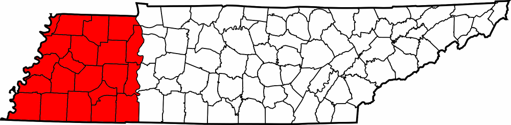
English: Map showing the counties of West Tennessee, United States. |
| Date | |
| Source | Own work; File:Tennessee county locator map - blank.png |
| Author | User:Huntster |
Licensing
| This file is licensed under the Creative Commons Attribution-Share Alike 3.0 Unported license. Subject to disclaimers. | ||
| ||
| This licensing tag was added to this file as part of the GFDL licensing update. |

|
Permission is granted to copy, distribute and/or modify this document under the terms of the GNU Free Documentation License, Version 1.2 or any later version published by the Free Software Foundation; with no Invariant Sections, no Front-Cover Texts, and no Back-Cover Texts. A copy of the license is included in the section entitled GNU Free Documentation License. Subject to disclaimers. |
Original upload log
Transferred from en.wikipedia to Commons using For the Common Good.
The original description page was
here. All following user names refer to en.wikipedia.
| Date/Time | Dimensions | User | Comment |
|---|---|---|---|
| 07:19, 4 June 2005 | 300 × 75 (11,229 bytes) | w:en:Dale Arnett ( talk | contribs) | (Public domain map courtesy of [http://www.lib.utexas.edu/ The General Libraries, The University of Texas at Austin], modified to show counties. {{GFDL}} See [[Wikipedia:U.S. county map]]s.) |
File history
Click on a date/time to view the file as it appeared at that time.
| Date/Time | Thumbnail | Dimensions | User | Comment | |
|---|---|---|---|---|---|
| current | 03:08, 24 May 2013 |
| 1,000 × 245 (34 KB) | Huntster | Introduce higher quality map. |
| 02:48, 24 May 2013 |
| 300 × 75 (11 KB) | Huntster | Transferred from en.wikipedia: see original upload log above |
File usage
The following pages on the English Wikipedia use this file (pages on other projects are not listed):
Global file usage
The following other wikis use this file:
- Usage on el.wikipedia.org
- Usage on fy.wikipedia.org
- Usage on gu.wikipedia.org
- Usage on it.wikipedia.org
- Usage on ja.wikipedia.org
- Usage on ko.wikipedia.org
- Usage on ru.wikipedia.org
- Usage on simple.wikipedia.org
- Usage on vi.wikipedia.org
- Usage on zh.wikipedia.org