No higher resolution available.
Map_of_USA_highlighting_Jello_Belt.png (280 × 183 pixels, file size: 37 KB, MIME type: image/png)
| This is a file from the
Wikimedia Commons. Information from its
description page there is shown below. Commons is a freely licensed media file repository. You can help. |
Summary

|
File:Mormon belt map with no outlines.svg is a vector version of this file. It should be used in place of this PNG file when not inferior.
File:Map of USA highlighting Jello Belt.png →
File:Mormon belt map with no outlines.svg
For more information, see
Help:SVG. |
 |
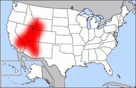
The Jell-O Belt (aka Mormon Corridor) indicated in red, overlaid on a US State map.
The image was transferred from en.wiki ( en:Image:Map_of_USA_highlighting_Jello_Belt.png) under the {{PD-because|}} license tag. Wars 05:53, 16 August 2006 (UTC)
See The Current State of the Mormon Culture Region for a map showing, by county, Leading Church Bodies from 2000. That map does not match this one exactly, because it shows only areas where the Church of Jesus Christ of Latter-day Saints is the largest religion.
Licensing
| This file is licensed under the Creative Commons Attribution-Share Alike 3.0 Unported license. Subject to disclaimers. | ||
| ||
| This licensing tag was added to this file as part of the GFDL licensing update. |

|
Permission is granted to copy, distribute and/or modify this document under the terms of the GNU Free Documentation License, Version 1.2 or any later version published by the Free Software Foundation; with no Invariant Sections, no Front-Cover Texts, and no Back-Cover Texts. A copy of the license is included in the section entitled GNU Free Documentation License. Subject to disclaimers. |
File history
Click on a date/time to view the file as it appeared at that time.
| Date/Time | Thumbnail | Dimensions | User | Comment | |
|---|---|---|---|---|---|
| current | 05:53, 16 August 2006 |
| 280 × 183 (37 KB) | Wars | The image was transferred from en.wiki ( en:Image:Map_of_USA_highlighting_Jello_Belt.png) under the '''<>{{PD-because|}}<>''' license tag. ~~~~ |
File usage
No pages on the English Wikipedia use this file (pages on other projects are not listed).
Global file usage
The following other wikis use this file:
- Usage on ar.wikipedia.org
- Usage on ast.wikipedia.org
- Usage on bg.wikipedia.org
- Usage on ca.wikipedia.org
- Usage on el.wikipedia.org
- Usage on eo.wikipedia.org
- Usage on es.wikipedia.org
- Usage on fr.wikipedia.org
- Usage on gl.wikipedia.org
- Usage on id.wikipedia.org
- Usage on it.wikipedia.org
- Usage on pl.wikipedia.org
- Usage on ro.wikipedia.org