
Size of this PNG preview of this SVG file:
517 × 599 pixels. Other resolutions:
207 × 240 pixels |
414 × 480 pixels |
663 × 768 pixels |
884 × 1,024 pixels |
1,767 × 2,048 pixels |
4,437 × 5,142 pixels.
Original file (SVG file, nominally 4,437 × 5,142 pixels, file size: 439 KB)
| This is a file from the
Wikimedia Commons. Information from its
description page there is shown below. Commons is a freely licensed media file repository. You can help. |
Summary
| Description |
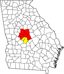
English: Locator map of the
Macon-Warner Robins-Fort Valley
Combined Statistical Area in the central part of the
U.S. state of
Georgia. The two components of the CSA are colored separately:
|
| Date | |
| Source | Own work, updated version of https://commons.wikimedia.org/wiki/File:Macon-Warner_Robins-Fort_Valley_CSA.png with current CSA counties using https://commons.wikimedia.org/wiki/File:Map_of_Georgia_highlighting_Houston_County.svg as a base. |
| Author | Lordsutch |
Licensing
I, the copyright holder of this work, hereby publish it under the following license:
This file is licensed under the
Creative Commons
Attribution-Share Alike 4.0 International license.
- You are free:
- to share – to copy, distribute and transmit the work
- to remix – to adapt the work
- Under the following conditions:
- attribution – You must give appropriate credit, provide a link to the license, and indicate if changes were made. You may do so in any reasonable manner, but not in any way that suggests the licensor endorses you or your use.
- share alike – If you remix, transform, or build upon the material, you must distribute your contributions under the same or compatible license as the original.
File history
Click on a date/time to view the file as it appeared at that time.
| Date/Time | Thumbnail | Dimensions | User | Comment | |
|---|---|---|---|---|---|
| current | 01:27, 29 June 2021 |
| 4,437 × 5,142 (439 KB) | Lordsutch | Removed Pulaski County from Warner Robins MSA |
| 06:51, 21 February 2018 |
 | 4,437 × 5,142 (439 KB) | Lordsutch | User created page with UploadWizard |
File usage
The following pages on the English Wikipedia use this file (pages on other projects are not listed):
- Allentown, Georgia
- Avondale, Georgia
- Bibb County, Georgia
- Bleckley County, Georgia
- Bolingbroke, Georgia
- Bonaire, Georgia
- Byron, Georgia
- Centerville, Georgia
- Central Georgia
- Clinchfield, Georgia
- Crawford County, Georgia
- Culloden, Georgia
- Danville, Georgia
- Dunbar, Georgia
- East Macon, Georgia
- Elberta, Georgia
- Elko, Georgia
- Forsyth, Georgia
- Fort Valley, Georgia
- Franklinton, Georgia
- Gray, Georgia
- Haddock, Georgia
- Hawkinsville, Georgia
- Houston County, Georgia
- Jeffersonville, Georgia
- Jones County, Georgia
- Juliette, Georgia
- Kathleen, Georgia
- Knoxville, Georgia
- Laurens County, Georgia
- Lizella, Georgia
- Macon, Georgia
- Macon metropolitan area, Georgia
- Monroe County, Georgia
- Musella, Georgia
- Payne, Georgia
- Peach County, Georgia
- Perry, Georgia
- Pulaski County, Georgia
- Roberta, Georgia
- Robins Air Force Base
- Rutland, Georgia
- Smarr, Georgia
- Sofkee, Georgia
- Twiggs County, Georgia
- Walden, Georgia
- Warner Robins, Georgia
- Warner Robins metropolitan area, Georgia
- Wilkinson County, Georgia
- Template:Macon Metro
- Category:Macon metropolitan area, Georgia
Global file usage
The following other wikis use this file:
- Usage on de.wikipedia.org
- Usage on es.wikipedia.org
- Usage on ja.wikipedia.org