Size of this preview:
800 × 550 pixels. Other resolutions:
320 × 220 pixels |
640 × 440 pixels |
1,024 × 704 pixels |
1,280 × 880 pixels |
1,983 × 1,363 pixels.
Original file (1,983 × 1,363 pixels, file size: 160 KB, MIME type: image/png)
| This is a file from the
Wikimedia Commons. Information from its
description page there is shown below. Commons is a freely licensed media file repository. You can help. |
| Description |
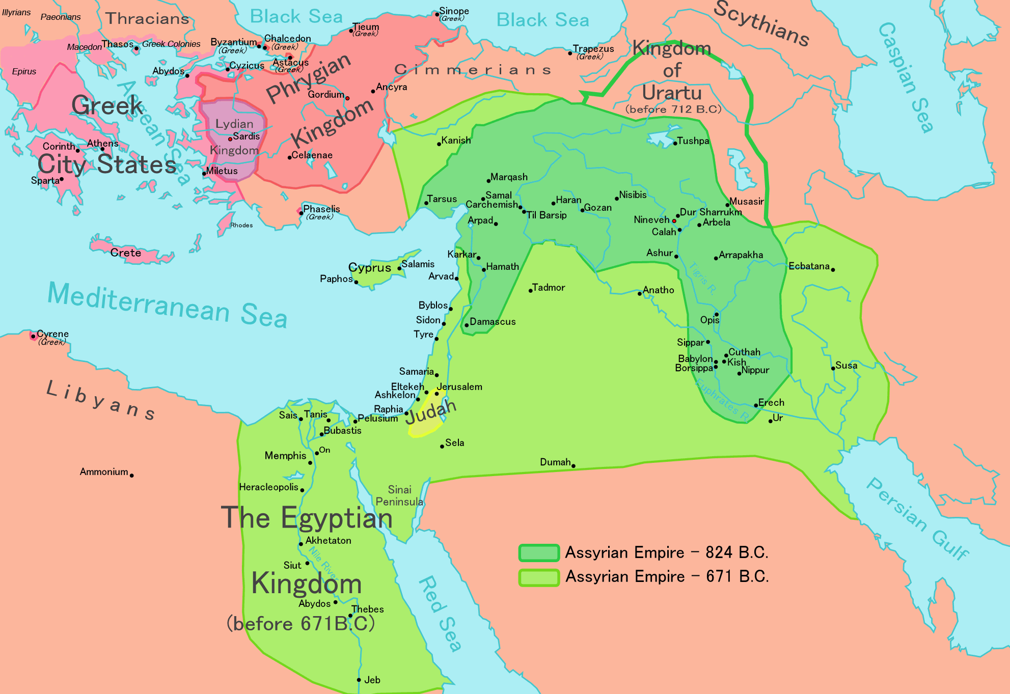
English: Map of the Assyrian Empire Español: Extensión del Imperio Asirio Polski: Mapa Asyrii w 824 i 671 r. p.n.e. Português: Extensão do Império Assírio العربية : خارطة الإمبراطوريَّة الآشوريَّة. فارسی : نقشه امپراتوری آشور |
|||
| Date | ||||
| Source |
Own work data from
|
|||
| Author | Ningyou | |||
| Permission ( Reusing this file) |
|
|||
| Other versions |
|


File history
Click on a date/time to view the file as it appeared at that time.
| Date/Time | Thumbnail | Dimensions | User | Comment | |
|---|---|---|---|---|---|
| current | 12:32, 24 May 2018 |
| 1,983 × 1,363 (160 KB) | Capmo | corrected typos in Trapezus and Hamath |
| 18:33, 12 September 2010 |
 | 1,983 × 1,363 (148 KB) | Ras67 | cropped and squeezed | |
| 00:35, 1 September 2010 |
 | 1,985 × 1,365 (161 KB) | Capmo | typo in word "Aegean"; 256 colors | |
| 21:05, 21 January 2010 |
 | 1,985 × 1,365 (645 KB) | Megistias | Border around map, Details | |
| 14:51, 26 February 2006 |
 | 1,985 × 1,365 (640 KB) | Ningyou | This is a large map of Assyria, made by Ningyou. For translations of this map, contact Ningyou. Category:Assyria |
File usage
The following pages on the English Wikipedia use this file (pages on other projects are not listed):
- 790s BC
- 7th century BC
- Aram-Damascus
- Assur
- Assyria
- Assyrian people
- Assyrian siege of Jerusalem
- Bit-Istar
- Bit Adini
- Bit Bahiani
- Carchemish
- Esarhaddon
- Fall of Ashdod
- Fall of Assur
- Gurgum
- History of Anatolia
- History of Iraq
- History of Israel
- History of the Assyrians
- Iraq
- Kammanu
- Kummuh
- List of ancient great powers
- List of conflicts in Asia
- List of conflicts in Iraq
- Luhuti
- Medo-Babylonian conquest of the Assyrian Empire
- Middle Eastern empires
- Military history of Iraq
- Nuhašše
- Pattin
- Pax Assyriaca
- Prehistory of Anatolia
- Sargonid dynasty
- Semiramis
- Sennacherib's campaign in the Levant
- Siege of Azekah
- Siege of Lachish
- State communications in the Neo-Assyrian Empire
- Timeline of Jerusalem
- Timeline of ancient Assyria
- Twenty-fifth Dynasty of Egypt
- Twenty-sixth Dynasty of Egypt
- Ḫilakku
- Talk:Tiglath-Pileser III
- User:A.X.Wiki.Editor/List of conflicts in Iraq
- User:Bobbylon
- User:DutchPatriot
- User:Evad37/Random slideshow sandbox testcases
- User:Falcaorib
- User:History of Persia/sandbox
- User:LightandDark2000
- User:LightandDark2000/Userboxes/Assyria
- User:Mawer10/sandbox3
- User:SomeGuyWhoRandomlyEdits/List of conflicts in the Near East
- User:Super Cyclonic Storm Corona/Userboxes/L&d2k's
- User:Vivaporius/Books/Neo-Assyrian Empire
- User:Yogeshpaliyal
- User:배우는사람/Test
- Portal:Iraq
- Portal:Israel
Global file usage
The following other wikis use this file:
- Usage on af.wikipedia.org
- Usage on als.wikipedia.org
- Usage on am.wikipedia.org
- Usage on an.wikipedia.org
- Usage on arc.wikipedia.org
- Usage on ar.wikipedia.org
- Usage on ast.wikipedia.org
- Usage on azb.wikipedia.org
- Usage on az.wikipedia.org
- Usage on ba.wikipedia.org
- Usage on be.wikipedia.org
- Usage on bg.wikipedia.org
- Usage on bn.wikipedia.org
- Usage on ca.wikipedia.org
- Usage on ckb.wikipedia.org
- Usage on cs.wikipedia.org
- Usage on cv.wikipedia.org
- Usage on cy.wikipedia.org
- Usage on dag.wikipedia.org
- Usage on da.wikipedia.org
- Usage on de.wikipedia.org
- Usage on el.wikipedia.org
View more global usage of this file.