
Size of this PNG preview of this SVG file:
800 × 423 pixels. Other resolutions:
320 × 169 pixels |
640 × 338 pixels |
1,024 × 541 pixels |
1,280 × 677 pixels |
2,560 × 1,353 pixels |
1,470 × 777 pixels.
Original file (SVG file, nominally 1,470 × 777 pixels, file size: 338 KB)
| This is a file from the
Wikimedia Commons. Information from its
description page there is shown below. Commons is a freely licensed media file repository. You can help. |
Summary
| Description |
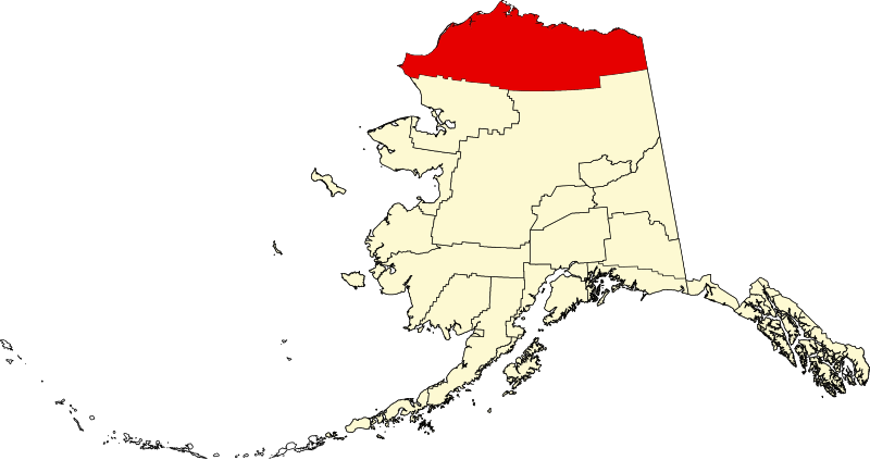
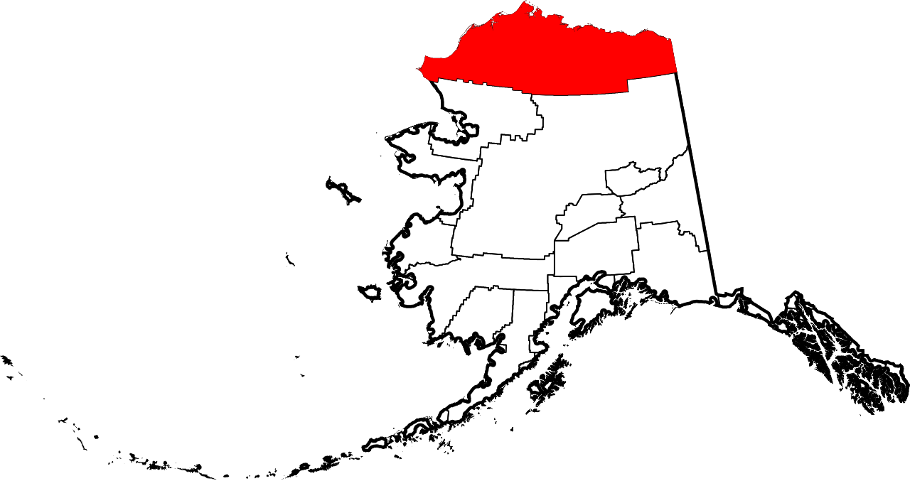
English: This is a locator map showing
North Slope Borough in Alaska |
| Date | |
| Source |
Own work: English: The maps use data from
nationalatlas.gov, specifically
countyp020.tar.gz on the
Raw Data Download page. The maps also use state outline data from
statesp020.tar.gz. The Florida maps use
hydrogm020.tar.gz to display Lake Okeechobee. |
| Author | David Benbennick |
| SVG development |
Licensing
| I, the copyright holder of this work, release this work into the
public domain. This applies worldwide. In some countries this may not be legally possible; if so: I grant anyone the right to use this work for any purpose, without any conditions, unless such conditions are required by law. |
File history
Click on a date/time to view the file as it appeared at that time.
| Date/Time | Thumbnail | Dimensions | User | Comment | |
|---|---|---|---|---|---|
| current | 19:28, 5 March 2006 |
| 1,470 × 777 (338 KB) | David Benbennick | {{subst:User:Dbenbenn/clm|county=North Slope Borough|state=Alaska|type=borough and census area}} |
File usage
More than 100 pages use this file. The following list shows the first 100 pages that use this file only. A full list is available.
- Adventure Creek
- Agiak Lagoon
- Akporvik Hill
- Akulik Creek
- Alpine, Alaska
- Alpine Airstrip
- Aluakpak
- Amatusuk Hills
- Amo Creek
- Anaktuvuk Pass
- Anaktuvuk Pass, Alaska
- Anxiety Point
- Archimedes Ridge
- Arey Island
- Arey Lagoon
- Atanik
- Atigun Pass
- Atqasuk, Alaska
- Avingak Creek
- Awuna River
- Canning River (Alaska)
- Cape Beaufort
- Cape Lisburne
- Cape Sabine (Alaska)
- Cape Sabine DEW Line Station
- Cape Thompson
- Chariot, Alaska
- Coleen River
- De Long Mountains
- Deadfall Creek
- Deadhorse, Alaska
- Disappointment Creek (Utukok River tributary)
- Driftwood Creek
- Elusive Creek
- Epizetka River
- Eskimo Hill
- Etivluk River
- Franklin Mountains (Alaska)
- Gull Island (Prudhoe Bay)
- Icy Cape
- Itkillik River
- Ivishak River
- Iñupiat
- KBRW-FM
- KBRW (AM)
- Kadleroshilik Pingo
- Kaktovik, Alaska
- Kaktovik numerals
- Kasegaluk Lagoon
- Kivalina River
- Kokolik River
- Kongakut River
- Kugrua Bay
- Kuk River
- Kukpowruk River
- Kukpuk River
- Kuparuk River
- Lisburne Peninsula
- List of boroughs and census areas in Alaska
- Meade River
- Meat Mountain
- Mollie Beattie Wilderness
- Mount Chamberlin (Alaska)
- Mount Hubley (Alaska)
- Mount Isto
- Mount Michelson (Brooks Range)
- National Register of Historic Places listings in North Slope Borough, Alaska
- Native Village of Barrow Inupiat Traditional Government
- Nigu River
- North Fork Koyukuk River
- North Slope Borough, Alaska
- Nuiqsut, Alaska
- Omicron Hill
- Peard Bay
- Pitmegea River
- Point Franklin
- Point Hope, Alaska
- Point Hope (cape)
- Point Hope Airport
- Point Lay, Alaska
- Poko Mountain
- Prudhoe Bay, Alaska
- Sagavanirktok River
- Sagwon, Alaska
- Seahorse Islands
- Tarn Oil Field
- Thetis Mound
- Ugnu–Kuparuk Airport
- Umiat, Alaska
- Utkeagvik Church Manse
- Utqiagvik, Alaska
- Utukok River
- Wainwright, Alaska
- Western Arctic National Parklands
- Wevok, Alaska
- Wind River (Yukon–Koyukuk Census Area, Alaska)
- Wulik River
- User:Nyttend/County templates/AK
- Wikipedia:WikiProject Alaska
- Template:NorthSlopeAK-geo-stub
View more links to this file.
Global file usage
The following other wikis use this file:
- Usage on ar.wikipedia.org
- Usage on azb.wikipedia.org
- Usage on az.wikipedia.org
- Usage on bpy.wikipedia.org
- Usage on ca.wikipedia.org
- Usage on ceb.wikipedia.org
- Usage on ce.wikipedia.org
- Usage on cy.wikipedia.org
- Usage on de.wikipedia.org
- Usage on es.wikipedia.org
- Usage on fa.wikipedia.org
- Usage on fi.wikipedia.org
- Usage on fo.wikipedia.org
- Usage on fr.wikipedia.org
View more global usage of this file.