No higher resolution available.
Map_Passaic_County_Paterson_NJ.gif (450 × 580 pixels, file size: 40 KB, MIME type: image/gif)
| This is a file from the
Wikimedia Commons. Information from its
description page there is shown below. Commons is a freely licensed media file repository. You can help. |
Summary
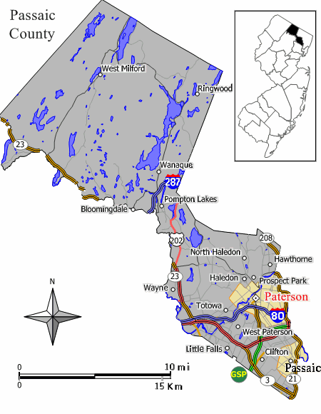
| Description | Closeup view of Map of Paterson in w:Passaic County, New Jersey (extracted from original map work by Jim Irwin, December 2005), with distance scale in miles/kilometers, Interstate-icons enlarged 50%, town names clarified, and edges cropped 130px (width 450px had been 580px). |
| Source | w:File:Paterson nj.png (cropped and magnified 30%, adding kilometer scale, and enlarging names/icons). |
| Author | JimIrwin, Wikid77 |
Licensing

|
Permission is granted to copy, distribute and/or modify this document under the terms of the GNU Free Documentation License, Version 1.2 or any later version published by the Free Software Foundation; with no Invariant Sections, no Front-Cover Texts, and no Back-Cover Texts. A copy of the license is included in the section entitled GNU Free Documentation License. |
| This file is licensed under the Creative Commons Attribution-Share Alike 3.0 Unported license. | ||
| ||
| This licensing tag was added to this file as part of the GFDL licensing update. |
Original upload log
The original description page was
here. All following user names refer to en.wikipedia.
| Date/Time | Dimensions | User | Comment |
|---|---|---|---|
| 2007-08-19 07:16:24 | 450 × 580 | Wikid77 | == Summary == Closeup view of Map of Paterson in [[Passaic County, New Jersey]] (extracted from original map work by Jim Irwin, December 2005), with distance scale in miles/kilometers, Interstate-icons enlarged 50%, town names clarified, and edges cropped |
File history
Click on a date/time to view the file as it appeared at that time.
| Date/Time | Thumbnail | Dimensions | User | Comment | |
|---|---|---|---|---|---|
| current | 23:38, 29 October 2018 |
| 450 × 580 (40 KB) | FSock | Transferred from en.wikipedia ( MTC!) (1.1.1) |
File usage
The following pages on the English Wikipedia use this file (pages on other projects are not listed):