
Size of this preview:
394 × 599 pixels. Other resolutions:
158 × 240 pixels |
400 × 608 pixels.
Original file (400 × 608 pixels, file size: 19 KB, MIME type: image/gif)
| This is a file from the
Wikimedia Commons. Information from its
description page there is shown below. Commons is a freely licensed media file repository. You can help. |
Summary
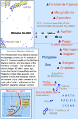
| Description | Map describing volcanoes of the Mariana Islands along the Marianas Trench (east of China and the Philippines). |
| Date | |
| Source | Derived by cropping US Government ( USGS) map: http://vulcan.wr.usgs.gov/Imgs/Gif/MarianaIslands/Maps/map_mariana_islands_volcanoes.gif |
| Author | Wikid77 |
Licensing
The map is public domain, derived by User:Wikid77 from a USGS image (in GIF format).
This work is in the
public domain in the United States because it is a
work prepared by an officer or employee of the United States Government as part of that person’s official duties under the terms of
Title 17, Chapter 1, Section 105 of the
US Code.
Note: This only applies to original works of the Federal Government and not to the work of any individual
U.S. state,
territory, commonwealth, county, municipality, or any other subdivision. This template also does not apply to postage stamp designs published by the
United States Postal Service
since 1978. (See §
313.6(C)(1) of Compendium of U.S. Copyright Office Practices). It also does not apply to certain US coins; see
The US Mint Terms of Use.
|
 | |
| This file has been identified as being free of known restrictions under copyright law, including all related and neighboring rights. | ||
File history
Click on a date/time to view the file as it appeared at that time.
| Date/Time | Thumbnail | Dimensions | User | Comment | |
|---|---|---|---|---|---|
| current | 19:55, 29 June 2010 |
| 400 × 608 (19 KB) | Ras67 | cropped |
| 14:23, 7 March 2008 |
 | 400 × 640 (21 KB) | Wikid77 | initial upload |
File usage
The following pages on the English Wikipedia use this file (pages on other projects are not listed):
Global file usage
The following other wikis use this file:
- Usage on af.wikipedia.org
- Usage on az.wikipedia.org
- Usage on br.wikipedia.org
- Usage on da.wikipedia.org
- Usage on fa.wikipedia.org
- Usage on fi.wikipedia.org
- Usage on fo.wikipedia.org
- Usage on gl.wikipedia.org
- Usage on io.wikipedia.org
- Usage on is.wikipedia.org
- Usage on ja.wikipedia.org
- Usage on la.wikipedia.org
- Usage on lt.wikipedia.org
- Usage on mk.wikipedia.org
- Usage on ms.wikipedia.org
- Usage on nl.wikipedia.org
- Usage on no.wikipedia.org
- Usage on pt.wikipedia.org
- Usage on sk.wikipedia.org
- Usage on sr.wikipedia.org
- Usage on th.wikipedia.org
- Usage on tl.wikipedia.org
- Usage on tr.wikipedia.org
- Usage on tr.wiktionary.org
- Usage on uk.wikipedia.org
- Usage on uz.wikipedia.org
- Usage on vi.wikipedia.org
- Usage on zh-yue.wikipedia.org