
Size of this preview:
800 × 600 pixels. Other resolutions:
320 × 240 pixels |
640 × 480 pixels |
1,024 × 768 pixels |
1,280 × 960 pixels |
2,560 × 1,920 pixels |
3,072 × 2,304 pixels.
Original file (3,072 × 2,304 pixels, file size: 1.21 MB, MIME type: image/jpeg)
| This is a file from the
Wikimedia Commons. Information from its
description page there is shown below. Commons is a freely licensed media file repository. You can help. |
.JPG)
| This is a
retouched picture, which means that it has been digitally altered from its original version. Modifications: Removed object on the bottom left hand of the image by clone stamp tool. The original can be viewed here:
Malakoff Diggins, State Historic Park.jpg:
|
| Description |
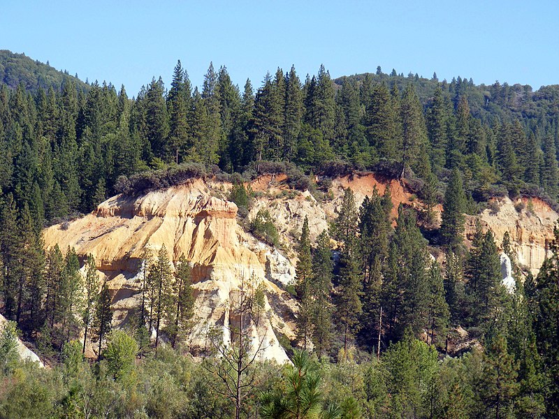
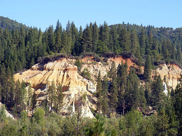
English:
w:Malakoff Diggins State Historic Park, located near Nevada City, CA.
Français : Parc historique de la « mine » de Malakoff (Malakoff Diggins), sis près de
Nevada City, en Californie (États-Unis d'Amérique). Cette falaise dénudée a été obtenue en détournant de l'eau afin de détruire cette colline et d'en extraire de l'or. |
| Date | |
| Source | Image:Malakoff Diggins, State Historic Park.jpg |
| Author | J.smith, Retouched by Mmxx |
| Camera location |
| View this and other nearby images on: OpenStreetMap |
|
|---|
.JPG¶ms=039.370167_N_-120.909611_E_globe:Earth_type:camera__&language=en)
Licensing
This file is licensed under the
Creative Commons
Attribution-Share Alike 3.0 Unported license.
- You are free:
- to share – to copy, distribute and transmit the work
- to remix – to adapt the work
- Under the following conditions:
- attribution – You must give appropriate credit, provide a link to the license, and indicate if changes were made. You may do so in any reasonable manner, but not in any way that suggests the licensor endorses you or your use.
- share alike – If you remix, transform, or build upon the material, you must distribute your contributions under the same or compatible license as the original.

|
This image has been assessed under the valued image criteria and is considered the most valued image on Commons within the scope: Malakoff Diggins State Historic Park. You can see its nomination here. |
.JPG)
 |
This photo was taken by
Justin Smith (User:J.smith) and released under the license(s) stated on this page. You are free to use this image as long as you follow the terms of the license and credit me properly. Example: © Justin Smith / Wikimedia Commons, CC-By-SA-3.0 If you use this image outside of Wikimedia projects I would appreciate (but do not require) being
informed. If you would like a license with the conditions of your choice, please e-mail (
commons's build-in system or at jsmith
|
 |
File history
Click on a date/time to view the file as it appeared at that time.
| Date/Time | Thumbnail | Dimensions | User | Comment | |
|---|---|---|---|---|---|
| current | 18:58, 14 October 2008 |
| 3,072 × 2,304 (1.21 MB) | J.smith | |
| 13:23, 11 October 2008 |
 | 3,072 × 2,304 (1.13 MB) | Mmxx | {{Information |Description= |Source= Image:Malakoff Diggins, State Historic Park.jpg |Date=October 9, 2008 |Author= J.smith |Permission= |other_versions= }} == Licensing: == {{self|cc-by-sa-3.0}} |
File usage
The following pages on the English Wikipedia use this file (pages on other projects are not listed):
Global file usage
The following other wikis use this file:
- Usage on ceb.wikipedia.org
- Usage on en.wikivoyage.org
- Usage on fa.wikipedia.org
- Usage on fr.wikipedia.org
- Usage on www.wikidata.org
.JPG)