
Size of this PNG preview of this SVG file:
709 × 600 pixels. Other resolutions:
284 × 240 pixels |
567 × 480 pixels |
908 × 768 pixels |
1,210 × 1,024 pixels |
2,420 × 2,048 pixels |
936 × 792 pixels.
Original file (SVG file, nominally 936 × 792 pixels, file size: 88 KB)
| This is a file from the
Wikimedia Commons. Information from its
description page there is shown below. Commons is a freely licensed media file repository. You can help. |
_Adoption.svg)
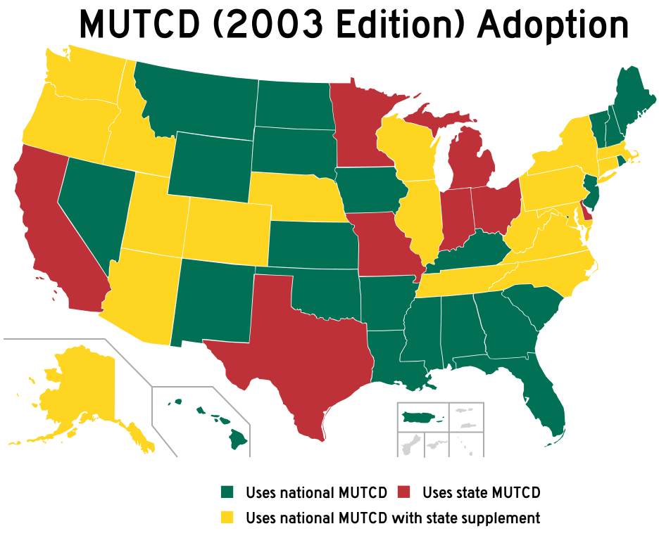
| Description | Modified to show MUTCD (2003 Edition) compliance of states | ||
| Date | (UTC) | ||
| Source | File:Blank USA, w territories.svg | ||
| Author | |||
| Other versions |
All the below are of the states (and DC) only.
|
||
| SVG development | This
map was created with
Adobe Illustrator.
|
I, the copyright holder of this work, hereby publish it under the following license:

|
Permission is granted to copy, distribute and/or modify this document under the terms of the GNU Free Documentation License, Version 1.2 or any later version published by the Free Software Foundation; with no Invariant Sections, no Front-Cover Texts, and no Back-Cover Texts. A copy of the license is included in the section entitled GNU Free Documentation License. |
| This file is licensed under the Creative Commons Attribution-Share Alike 3.0 Unported license. | ||
| ||
| This licensing tag was added to this file as part of the GFDL licensing update. |
Original upload log
This image is a derivative work of the following images:
- File:
Blank USA, w territories.svg licensed with GFDL
- 2009-01-30T01:59:59Z Hoshie 959x593 (98189 Bytes) Reverted to version as of 23:58, 14 January 2009 - rv myself; DC can be seen clearly.
- 2009-01-18T23:34:42Z Hoshie 959x593 (102341 Bytes) Put DC in an inset; fixed Tutuila (American Samoa)
- 2009-01-14T23:58:05Z Lokal Profil 959x593 (98189 Bytes) Code cleanup and removed stroke from Guam and American Samoa
- 2009-01-13T05:19:51Z Hoshie 959x593 (101361 Bytes) re did Guam and added American Samoa
- 2007-12-02T16:08:45Z Lokal Profil 959x593 (88960 Bytes) {{Information |Description=A blank map of the United States including Puerto Rico, Guam, the United States Virgin Islands, and the Northern Mariana Islands. |Source=This version was made by [[:User:Lokal_Profil|Lokal_Profil]]
Uploaded with derivativeFX
File history
Click on a date/time to view the file as it appeared at that time.
| Date/Time | Thumbnail | Dimensions | User | Comment | |
|---|---|---|---|---|---|
| current | 20:32, 7 April 2009 |
| 936 × 792 (88 KB) | Overpush~commonswiki | corrections |
| 15:58, 7 April 2009 |
 | 936 × 792 (88 KB) | Overpush~commonswiki | Updated info | |
| 15:57, 7 April 2009 |
 | 936 × 792 (88 KB) | Overpush~commonswiki | Updated info | |
| 22:53, 6 April 2009 |
 | 936 × 792 (87 KB) | Overpush~commonswiki | {{Information |Description=Modified to show MUTCD (2003 Edition) compliance of states |Source=* File:Blank_USA,_w_territories.svg |Date=2009-04-06 23:53 (UTC) |Author=* File:Blank_USA,_w_territories.svg: Lokal_Profil |othe |
File usage
No pages on the English Wikipedia use this file (pages on other projects are not listed).
Global file usage
The following other wikis use this file:
- Usage on ja.wikipedia.org
- Usage on ru.wikipedia.org
- Usage on vi.wikipedia.org
- Usage on zh.wikipedia.org
_Adoption.svg)