
Size of this preview:
800 × 573 pixels. Other resolutions:
320 × 229 pixels |
640 × 459 pixels |
1,024 × 734 pixels |
1,280 × 918 pixels |
2,560 × 1,835 pixels |
7,230 × 5,183 pixels.
Original file (7,230 × 5,183 pixels, file size: 19.16 MB, MIME type: image/jpeg)
| This is a file from the
Wikimedia Commons. Information from its
description page there is shown below. Commons is a freely licensed media file repository. You can help. |
Summary
| Title |
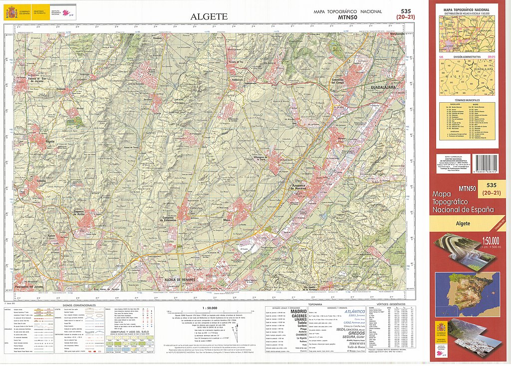
Mapa MTN50-0535-2013-cns Algete |
||||||||||||||||||||
| Description |
Español: Fragmento 0535 del Mapa Topográfico Nacional de España (MTN) del año 2013, a escala 1:50000, impreso y escaneado a 250 ppp. Representa a Algete.
English: Fragment 0535 of the National Topographic Map of Spain in 2013, at a scale of 1:50000 printed and scanned with a resolution of 250 ppi. It shows Algete. |
||||||||||||||||||||
| Date | |||||||||||||||||||||
| Source | Centro de descargas del CNIG | ||||||||||||||||||||
| Creator |
|
||||||||||||||||||||
| Permission ( Reusing this file) |
This file is licensed under the
Creative Commons
Attribution 4.0 International license. Attribution:
Instituto Geográfico Nacional (
archived version)
|
||||||||||||||||||||
| Geotemporal data | |||||||||||||||||||||
| Map location | Algete (Q472604) | ||||||||||||||||||||
| Map type | topographic map (Q216526) | ||||||||||||||||||||
| Scale | 1:50,000 | ||||||||||||||||||||
| Georeferencing | If inappropriate please set warp_status = skip to hide. | ||||||||||||||||||||
| Bibliographic data | |||||||||||||||||||||
| Part of the series | National Topographic Map 1:50000 printed (Q60544056) | ||||||||||||||||||||
| Map sheet | 0535 | ||||||||||||||||||||
| Language | Spanish | ||||||||||||||||||||
| Place of publication | Madrid (Q2807) | ||||||||||||||||||||
| Publisher |
|
||||||||||||||||||||
| Archival data | |||||||||||||||||||||
| Collection |
|
||||||||||||||||||||
| Notes |
|
||||||||||||||||||||
Licensing
This file is licensed under the
Creative Commons
Attribution 4.0 International license.
- You are free:
- to share – to copy, distribute and transmit the work
- to remix – to adapt the work
- Under the following conditions:
- attribution – You must give appropriate credit, provide a link to the license, and indicate if changes were made. You may do so in any reasonable manner, but not in any way that suggests the licensor endorses you or your use.
File history
Click on a date/time to view the file as it appeared at that time.
| Date/Time | Thumbnail | Dimensions | User | Comment | |
|---|---|---|---|---|---|
| current | 19:50, 8 July 2021 |
| 7,230 × 5,183 (19.16 MB) | Raimundo Pastor | Uploaded own work with UploadWizard |
File usage
The following pages on the English Wikipedia use this file (pages on other projects are not listed):
Global file usage
The following other wikis use this file:
- Usage on es.wikipedia.org