Size of this preview:
272 × 599 pixels. Other resolutions:
109 × 240 pixels |
218 × 480 pixels |
860 × 1,893 pixels.
Original file (860 × 1,893 pixels, file size: 487 KB, MIME type: image/png)
| This is a file from the
Wikimedia Commons. Information from its
description page there is shown below. Commons is a freely licensed media file repository. You can help. |
Summary
| Description |
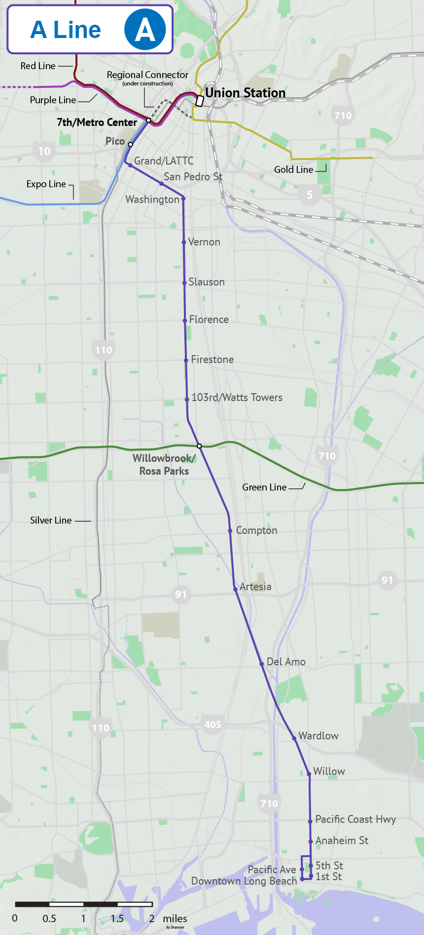
English: A geographically accurate map of the Blue Line in Los Angeles County, including the planned extension to Union Station via Regional Connector. Dashed lines indicate under construction or planned Metro routes. Gray checkered lines indicate Metrolink routes. |
| Date | |
| Source | Own work |
| Author | Shannon1 |
Licensing
I, the copyright holder of this work, hereby publish it under the following licenses:

|
Permission is granted to copy, distribute and/or modify this document under the terms of the GNU Free Documentation License, Version 1.2 or any later version published by the Free Software Foundation; with no Invariant Sections, no Front-Cover Texts, and no Back-Cover Texts. A copy of the license is included in the section entitled GNU Free Documentation License. |
This file is licensed under the
Creative Commons Attribution-Share Alike
4.0 International,
3.0 Unported,
2.5 Generic,
2.0 Generic and
1.0 Generic license.
- You are free:
- to share – to copy, distribute and transmit the work
- to remix – to adapt the work
- Under the following conditions:
- attribution – You must give appropriate credit, provide a link to the license, and indicate if changes were made. You may do so in any reasonable manner, but not in any way that suggests the licensor endorses you or your use.
- share alike – If you remix, transform, or build upon the material, you must distribute your contributions under the same or compatible license as the original.
You may select the license of your choice.
File history
Click on a date/time to view the file as it appeared at that time.
| Date/Time | Thumbnail | Dimensions | User | Comment | |
|---|---|---|---|---|---|
| current | 21:07, 22 July 2020 |
| 860 × 1,893 (487 KB) | Lexlex | Change name to A Line |
| 22:24, 8 November 2017 |
 | 860 × 1,893 (475 KB) | Shannon1 | cleaned up and made more accurate | |
| 19:18, 24 July 2017 |
 | 513 × 1,144 (276 KB) | Shannon1 | {{Information |Description ={{en|1=A geographically accurate map of the Blue Line in Los Angeles County. Dashed lines indicate under construction or planned Metro routes. Gray checkered lines indicate Metrolink routes. }} |Source =Own work |... |
File usage
No pages on the English Wikipedia use this file (pages on other projects are not listed).
Global file usage
The following other wikis use this file:
- Usage on ko.wikipedia.org
- Usage on www.wikidata.org