Size of this PNG preview of this SVG file:
715 × 600 pixels. Other resolutions:
286 × 240 pixels |
572 × 480 pixels |
916 × 768 pixels |
1,221 × 1,024 pixels |
2,442 × 2,048 pixels |
4,542 × 3,809 pixels.
Original file (SVG file, nominally 4,542 × 3,809 pixels, file size: 46 KB)
File history
Click on a date/time to view the file as it appeared at that time.
| Date/Time | Thumbnail | Dimensions | User | Comment | |
|---|---|---|---|---|---|
| current | 11:45, 29 October 2022 |
 | 4,542 × 3,809 (46 KB) | Hanif Al Husaini | Lighten background to make higher contrast with the green text and line for the South Circular |
| 01:17, 13 May 2019 |
 | 4,542 × 3,809 (46 KB) | MetrolandNW | Further pinpoint fixes for accuracy, added other notable places | |
| 22:00, 11 May 2019 |
 | 4,542 × 3,809 (43 KB) | MetrolandNW | Fixes for place names (now mentions major places near/on the roads), corrected words' locations for accuracy ('Friern Barnet' especially was extremely unaccurate), coloured 'NORTH CIRCULAR' and 'SOUTH CIRCULAR' (to their respective lines' colours) | |
| 22:15, 24 March 2008 |
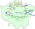
 | 4,542 × 3,809 (39 KB) | Cnbrb | {{Information |Description=An outline map of the North Circular and South Circular roads, including the Woolwich Ferry linking the two. |Source=self-made |Date=2008-03-24 |Author= Cnbrb |Permission= |other_versions= }} | |
| 22:01, 24 March 2008 |
 | 4,542 × 3,809 (40 KB) | Cnbrb | {{Information |Description=An outline map of the North Circular and South Circular roads, including the Woolwich Ferry linking the two. |Source=self-made |Date=2008-03-24 |Author= Cnbrb |Permission= |other_versions= }} |
File usage
The following pages on the English Wikipedia use this file (pages on other projects are not listed):
Global file usage
The following other wikis use this file:
- Usage on ga.wikipedia.org
- Usage on no.wikipedia.org
- Usage on simple.wikipedia.org
- Usage on uk.wikipedia.org
- Usage on www.wikidata.org
