
Size of this preview:
800 × 565 pixels. Other resolutions:
320 × 226 pixels |
640 × 452 pixels |
1,024 × 724 pixels |
1,280 × 904 pixels |
2,560 × 1,809 pixels |
4,284 × 3,027 pixels.
Original file (4,284 × 3,027 pixels, file size: 5.45 MB, MIME type: image/jpeg)
| This is a file from the
Wikimedia Commons. Information from its
description page there is shown below. Commons is a freely licensed media file repository. You can help. |
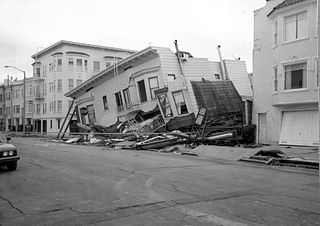
| Description | Loma Prieta, California, Earthquake October 17, 1989. Structures damaged in the Marina District of San Francisco. The first story of this three-story building was damaged because of liquefaction; the second story collapsed. What is seen is the third story. Figure 24B, U.S. Geological Survey Circular 1045. | |||
| Date | ||||
| Source | U.S. Department of the Interior U.S. Geological Survey photo via [1] | |||
| Author | G. Plafker | |||
| Permission ( Reusing this file) |
|
File history
Click on a date/time to view the file as it appeared at that time.
| Date/Time | Thumbnail | Dimensions | User | Comment | |
|---|---|---|---|---|---|
| current | 00:58, 5 July 2008 |
| 4,284 × 3,027 (5.45 MB) | Infrogmation | {{Information |Description= Loma Prieta, California, Earthquake October 17, 1989. Structures damaged in the Marina District of San Francisco. The first story of this three-story building was damaged because of liquefaction; the second story collapsed. Wha |
File usage
The following pages on the English Wikipedia use this file (pages on other projects are not listed):