
No higher resolution available.
LomaPrieta-Hwy1.jpeg (766 × 512 pixels, file size: 56 KB, MIME type: image/jpeg)
| This is a file from the
Wikimedia Commons. Information from its
description page there is shown below. Commons is a freely licensed media file repository. You can help. |
Summary
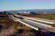
| Description | photograph of California State Route 1 section collapse after the Loma Prieta earthquake |
| Date | |
| Source | http://pubs.usgs.gov/dds/dds-29/web_pages/watsonville.html |
| Author | J.C. Tinsley, United States Geological Survey |
| Permission ( Reusing this file) |
"Feel free to use any of these images but please cite the photographer and the U.S. Geological Survey." |
| Other versions | http://pubs.usgs.gov/dds/dds-29/thumbs/094tn.gif |
Licensing
This image is in the
public domain in the United States because it only contains materials that originally came from the
United States Geological Survey, an agency of the
United States Department of the Interior. For more information, see
the official USGS copyright policy.
|
File history
Click on a date/time to view the file as it appeared at that time.
| Date/Time | Thumbnail | Dimensions | User | Comment | |
|---|---|---|---|---|---|
| current | 21:34, 15 April 2008 |
| 766 × 512 (56 KB) | Binksternet | == Summary == {{Information |Description=photograph of California State Route 1 section collapse after the Loma Prieta earthquake |Source=http://pubs.usgs.gov/dds/dds-29/web_pages/watsonville.html |Date=October 1989 |Author=J.C. Tinsley, United States Geo |
File usage
The following pages on the English Wikipedia use this file (pages on other projects are not listed):