
Size of this PNG preview of this SVG file:
613 × 600 pixels. Other resolutions:
245 × 240 pixels |
491 × 480 pixels |
785 × 768 pixels |
1,046 × 1,024 pixels |
2,093 × 2,048 pixels |
1,165 × 1,140 pixels.
Original file (SVG file, nominally 1,165 × 1,140 pixels, file size: 156 KB)
| This is a file from the
Wikimedia Commons. Information from its
description page there is shown below. Commons is a freely licensed media file repository. You can help. |
Summary
| Description |
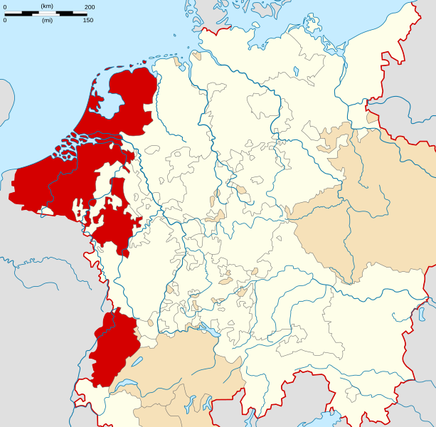
English: Locator Map of the Burgundian Circle of Holy Roman Empire. |
| Date | |
| Source | PERTHES ATLAS Geschichte |
| Author | Sir Iain |
| Permission ( Reusing this file) |
Attribution ShareAlike 3.0 |
| SVG development | This
vector image was created with
Inkscape. |
Licensing
This file is licensed under the
Creative Commons
Attribution-Share Alike 3.0 Unported license.
- You are free:
- to share – to copy, distribute and transmit the work
- to remix – to adapt the work
- Under the following conditions:
- attribution – You must give appropriate credit, provide a link to the license, and indicate if changes were made. You may do so in any reasonable manner, but not in any way that suggests the licensor endorses you or your use.
- share alike – If you remix, transform, or build upon the material, you must distribute your contributions under the same or compatible license as the original.
File history
Click on a date/time to view the file as it appeared at that time.
| Date/Time | Thumbnail | Dimensions | User | Comment | |
|---|---|---|---|---|---|
| current | 20:29, 23 November 2017 |
| 1,165 × 1,140 (156 KB) | Ras67 | frame removed |
| 16:18, 28 March 2010 |
 | 1,165 × 1,140 (193 KB) | Sir Iain | {{Information |Description=Locator Map of the Burgundian Circle of Holy Roman Empire. |Source=PERTHES ATLAS Geschichte |Date=28/03/2010 |Author=Sir Iain |Permission=Attribution ShareAlike 3.0 |other_versions= }} {{cc-by-sa-3.0}} [[Category:Reichskreise] |
File usage
The following pages on the English Wikipedia use this file (pages on other projects are not listed):
- Antwerp
- Breda
- Burgundian Circle
- Count of Holland
- County of Artois
- County of Burgundy
- County of Drenthe
- County of Flanders
- County of Hainaut
- County of Namur
- County of Zeeland
- Drenthe
- Duchy of Brabant
- Duchy of Guelders
- Duchy of Limburg
- Duchy of Luxembourg
- Free City of Besançon
- Free Imperial City of Besançon
- Groningen (province)
- Kingdom of Burgundy
- List of counts and margraves of Namur
- Lordship of Groningen
- Lordship of Mechelen
- Lordship of Overijssel
- Lordship of Utrecht
- Margraviate of Antwerp
- Mechelen
- Nijmegen Quarter
- Seventeen Provinces
- Veluwe Quarter
- Zutphen
- Wikipedia:WikiProject Former countries/Holy Roman Empire task force
- Template:Burgundian Circle
Global file usage
The following other wikis use this file:
- Usage on ar.wikipedia.org
- جمهورية هولندا
- الإمبراطورية الرومانية المقدسة
- درنتة
- مقاطعة خرننغن
- أفريسل
- زيلند (مقاطعة هولندية)
- صلح وستفاليا
- صلح البرانس
- بريدا
- كونتية فلانديرز
- قالب:الأقاليم السبعة عشر
- فريزيا
- الأقاليم السبعة عشر
- أسقفية أوترخت
- كونتية هولندا
- دوقية برابنت
- خيلدرز
- كونتية هينو
- كونت هولندا
- زوتفن
- لودرية أوتريخت
- مقاطعة زيلاند
- دوقية ليمبورغ
- كونتية أرتوا
- كونتات نامور
- دوقية لوكسمبورغ
- كونتية نامور
- ربع فيلوفه
- ربع نايميخن
- لوردية ميشيلين
- بوابة:الإمبراطورية الرومانية المقدسة
- بوابة:الإمبراطورية الرومانية المقدسة/قوالب
- Usage on bg.wikipedia.org
- Usage on cs.wikipedia.org
- Usage on el.wikipedia.org
- Usage on es.wikipedia.org
- Usage on et.wikipedia.org
- Usage on fr.wikipedia.org
- Pays-Bas autrichiens
- Pragmatique Sanction (1549)
- Cercle de Bourgogne
- Discussion:Cercle de Bourgogne
- Wikipédia:Le saviez-vous ?/Archives/2015
- Wikipédia:Statistiques des anecdotes de la page d'accueil/Visibilité des anecdotes (2015)
- Wikipédia:Statistiques des anecdotes de la page d'accueil/Visibilité des anecdotes (2015)/2015 08
- Utilisateur:GhosterBot/Log/Archives/2015/août
- Ville libre d'Empire de Besançon
- Usage on it.wikipedia.org
- Usage on lb.wikipedia.org
View more global usage of this file.