
Size of this PNG preview of this SVG file:
700 × 600 pixels. Other resolutions:
280 × 240 pixels |
560 × 480 pixels |
896 × 768 pixels |
1,195 × 1,024 pixels |
2,389 × 2,048 pixels.
Original file (SVG file, nominally 896 × 768 pixels, file size: 418 KB)
| This is a file from the
Wikimedia Commons. Information from its
description page there is shown below. Commons is a freely licensed media file repository. You can help. |
Summary
| Description |
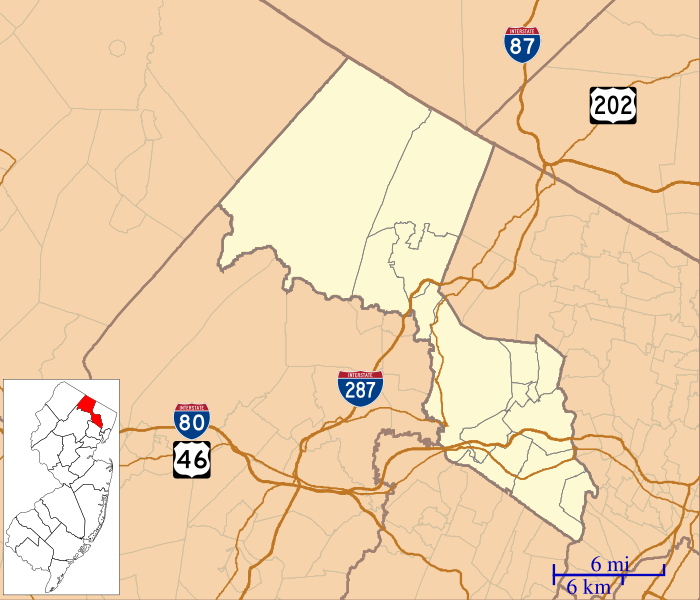
English: This is a map of
Passaic County, New Jersey, USA which includes incorporated settlements, township borders, and major highways. |
| Date | |
| Source | My own work, using custom-written MapScript applications with United States Census Bureau data |
| Author | Omnedon |
Licensing
| I, the copyright holder of this work, release this work into the
public domain. This applies worldwide. In some countries this may not be legally possible; if so: I grant anyone the right to use this work for any purpose, without any conditions, unless such conditions are required by law. |
File history
Click on a date/time to view the file as it appeared at that time.
| Date/Time | Thumbnail | Dimensions | User | Comment | |
|---|---|---|---|---|---|
| current | 05:50, 23 September 2012 |
| 896 × 768 (418 KB) | Omnedon | == {{int:filedesc}} == {{Information |Description={{en|This is a map of Passaic County, New Jersey, USA which includes incorporated settlements, township borders, and major highways.}} |Source=My own work, using custom... |
File usage
The following pages on the English Wikipedia use this file (pages on other projects are not listed):
- Ailsa Farms
- Aycrigg Mansion
- Bloomingdale, New Jersey
- Botany Worsted Mills Historic District
- Cathedral of St. John the Baptist (Paterson, New Jersey)
- Cathedral of St. Michael the Archangel (Passaic, New Jersey)
- Clifton, New Jersey
- Clinton Furnace
- Danforth Memorial Library
- Daniel Thompson and John Ryle Houses
- Dey Mansion
- Downtown Paterson
- Dundee Canal
- Eastside Park (neighborhood), Paterson
- Federal Hill (Bloomingdale, New Jersey)
- Frederick William Cooke Residence
- Garret Mountain Reservation
- Garritse–Doremus–Westervelt House
- Goffle Brook Park
- Great Falls (Passaic River)
- Great Notch, New Jersey
- Greenwood Lake
- Haledon, New Jersey
- Haskell, New Jersey
- Hawthorne, New Jersey
- Hewitt, New Jersey
- Hickory Mountain (New Jersey)
- John W. Ferguson House
- John W. Rea House
- John and Anna Vreeland House
- Kossuth Street School
- Lambert Castle
- Little Falls, New Jersey
- Long Pond Ironworks State Park
- Macopin, New Jersey
- Mead–Van Duyne House
- Newfoundland, New Jersey
- North Haledon, New Jersey
- Oak Ridge, New Jersey
- Packanack Lake, New Jersey
- Passaic, New Jersey
- Passaic County Court House
- Passaic Elks Club
- Paterson, New Jersey
- Paterson City Hall
- People's Bank and Trust Company Building
- Pietro and Maria Botto House
- Pines Lake, New Jersey
- Pompton Lakes, New Jersey
- Preakness, New Jersey
- Prospect Park, New Jersey
- Public School Number Two
- Reinhardt Mills
- Reynier Speer House
- Ringwood, New Jersey
- Ringwood Manor
- Schuyler–Colfax House
- Singac, New Jersey
- Skylands (estate)
- St. John's Evangelical Lutheran Church (Passaic, New Jersey)
- St. Michael's Roman Catholic Church
- St. Nicholas Catholic Church (Passaic, New Jersey)
- Totowa, New Jersey
- U.S. Animal Quarantine Station
- Upper Greenwood Lake, New Jersey
- Van Riper–Hopper House
- Wanaque, New Jersey
- Wayne, New Jersey
- West Milford, New Jersey
- Westside Park (Paterson, New Jersey)
- William Paterson University
- Woodland Park, New Jersey
- Module:Location map/data/USA New Jersey Passaic County
- Module:Location map/data/USA New Jersey Passaic County/doc
Global file usage
The following other wikis use this file:
- Usage on ar.wikipedia.org
- Usage on azb.wikipedia.org
- Usage on ceb.wikipedia.org
- Usage on fa.wikipedia.org
- Usage on fr.wikipedia.org
- Usage on kn.wikipedia.org
- Usage on simple.wikipedia.org
- Usage on si.wikipedia.org
- Usage on tr.wikipedia.org
- Usage on war.wikipedia.org