
Size of this PNG preview of this SVG file:
600 × 600 pixels. Other resolutions:
240 × 240 pixels |
480 × 480 pixels |
768 × 768 pixels |
1,024 × 1,024 pixels |
2,048 × 2,048 pixels.
Original file (SVG file, nominally 768 × 768 pixels, file size: 196 KB)
| This is a file from the
Wikimedia Commons. Information from its
description page there is shown below. Commons is a freely licensed media file repository. You can help. |
Summary
| Description |
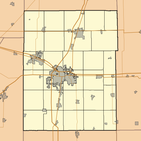
English: This is a map of
Champaign County, Illinois, USA which includes township borders. |
| Date | |
| Source | My own work, using custom-written MapScript applications with National Atlas and United States Census Bureau data |
| Author | Omnedon |
Licensing
| I, the copyright holder of this work, release this work into the
public domain. This applies worldwide. In some countries this may not be legally possible; if so: I grant anyone the right to use this work for any purpose, without any conditions, unless such conditions are required by law. |
File history
Click on a date/time to view the file as it appeared at that time.
| Date/Time | Thumbnail | Dimensions | User | Comment | |
|---|---|---|---|---|---|
| current | 00:51, 30 November 2010 |
| 768 × 768 (196 KB) | Omnedon | == {{int:filedesc}} == {{Information |Description={{en|This is a map of Champaign County, Illinois, USA which includes township borders.}} |Source=My own work, using custom-written MapScript applications with [http://www. |
File usage
The following pages on the English Wikipedia use this file (pages on other projects are not listed):
- Frasca Field
- Gifford, Illinois
- Homer, Illinois
- Ivesdale, Illinois
- Longview, Illinois
- Ludlow, Illinois
- Mahomet, Illinois
- Ogden, Illinois
- Pesotum, Illinois
- Philo, Illinois
- Rantoul, Illinois
- Royal, Illinois
- Sadorus, Illinois
- Savoy, Illinois
- Sidney, Illinois
- St. Joseph, Illinois
- Thomasboro, Illinois
- Tolono, Illinois
- Module:Location map/data/USA Illinois Champaign County
- Module:Location map/data/USA Illinois Champaign County/doc
Global file usage
The following other wikis use this file:
- Usage on ar.wikipedia.org
- Usage on azb.wikipedia.org
- Usage on bn.wikipedia.org
- Usage on ceb.wikipedia.org
- Usage on fa.wikipedia.org
- Usage on fr.wikipedia.org
- Usage on kn.wikipedia.org
- Usage on new.wikipedia.org
- Usage on sh.wikipedia.org
- St. Joseph, Illinois
- Sidney, Illinois
- Tolono, Illinois
- Fisher, Illinois
- Thomasboro, Illinois
- Savoy, Illinois
- Royal, Illinois
- Foosland, Illinois
- Philo, Illinois
- Homer, Illinois
- Ogden, Illinois
- Ludlow, Illinois
- Longview, Illinois
- Mahomet, Illinois
- Pesotum, Illinois
- Sadorus, Illinois
- Ivesdale, Illinois
- Gifford, Illinois
- Bondville, Illinois
- Broadlands, Illinois
- Usage on simple.wikipedia.org
- Usage on si.wikipedia.org
- Usage on sr.wikipedia.org
View more global usage of this file.