
Size of this preview:
521 × 599 pixels. Other resolutions:
209 × 240 pixels |
417 × 480 pixels |
850 × 978 pixels.
Original file (850 × 978 pixels, file size: 139 KB, MIME type: image/jpeg)
| This is a file from the
Wikimedia Commons. Information from its
description page there is shown below. Commons is a freely licensed media file repository. You can help. |
Summary
| Camera location |
| View this and other nearby images on: OpenStreetMap |
|
|---|
| Description |
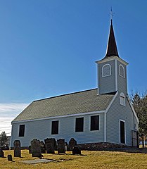
Français : L'Église «Little Ducth» à Halifax, désignée lieu historique national du Canada en 1996
|
This photo is of a
cultural heritage site in Canada, number
3252
|
|
This photo is of a
cultural heritage site in Canada, number
6482
|
|
| Date | |
| Source | https://www.flickr.com/photos/archer10/2284450048/ |
| Author | archer10 (Dennis) |
Licensing
| This image was originally posted to Flickr by archer10 (Dennis) at https://www.flickr.com/photos/22490717@N02/2284450048. It was reviewed on 5 December 2011 by FlickreviewR and was confirmed to be licensed under the terms of the cc-by-sa-2.0. |
This file is licensed under the
Creative Commons
Attribution-Share Alike 2.0 Generic license.
- You are free:
- to share – to copy, distribute and transmit the work
- to remix – to adapt the work
- Under the following conditions:
- attribution – You must give appropriate credit, provide a link to the license, and indicate if changes were made. You may do so in any reasonable manner, but not in any way that suggests the licensor endorses you or your use.
- share alike – If you remix, transform, or build upon the material, you must distribute your contributions under the same or compatible license as the original.
File history
Click on a date/time to view the file as it appeared at that time.
| Date/Time | Thumbnail | Dimensions | User | Comment | |
|---|---|---|---|---|---|
| current | 23:15, 31 January 2021 |
| 850 × 978 (139 KB) | De Insomniis | Cropped |
| 05:05, 5 December 2011 |
 | 850 × 1,280 (232 KB) | Fralambert |
File usage
The following pages on the English Wikipedia use this file (pages on other projects are not listed):
Global file usage
The following other wikis use this file:
- Usage on de.wikipedia.org
- Usage on fr.wikipedia.org
- Usage on ko.wikipedia.org
- Usage on www.wikidata.org
- Usage on zh.wikipedia.org