Size of this preview:
552 × 599 pixels. Other resolutions:
221 × 240 pixels |
442 × 480 pixels |
708 × 768 pixels |
1,138 × 1,235 pixels.
Original file (1,138 × 1,235 pixels, file size: 356 KB, MIME type: image/png)
| This is a file from the
Wikimedia Commons. Information from its
description page there is shown below. Commons is a freely licensed media file repository. You can help. |
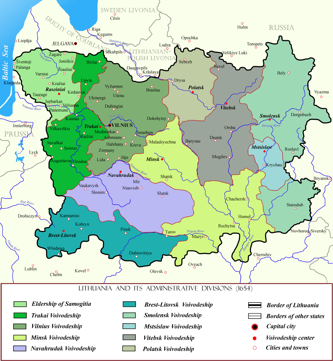
| Description | Lithuanian state in the 17th centuries with administrative divisions. |
| Date | |
| Source | Also used this additional pattern |
| Author | M.K. |
| Permission ( Reusing this file) |
This file is licensed under the
Creative Commons
Attribution-Share Alike 2.5 Generic license. Attribution: You must make credit to author of this image for using this image elsewhere.
|

|
This historical map image could be re-created using
vector graphics as an
SVG file. This has several advantages; see
Commons:Media for cleanup for more information. If an SVG form of this image is available, please upload it and afterwards replace this template with
{{
vector version available|new image name}}
.
It is recommended to name the SVG file “Lithuania in the 17th century.svg”—then the template Vector version available (or Vva) does not need the new image name parameter. |
File history
Click on a date/time to view the file as it appeared at that time.
| Date/Time | Thumbnail | Dimensions | User | Comment | |
|---|---|---|---|---|---|
| current | 01:49, 26 July 2010 |
| 1,138 × 1,235 (356 KB) | Mahahahaneapneap | Compressed |
| 13:58, 19 September 2007 |
 | 1,138 × 1,235 (491 KB) | M.K. | ||
| 20:29, 18 September 2007 |
 | 1,138 × 1,235 (486 KB) | M.K. | ||
| 17:54, 18 September 2007 |
 | 1,138 × 1,235 (484 KB) | M.K. | {{Information |Description= Lithuanian state in the 17th centuries with administrative divisions. |Source= Also used [http://lt.wikipedia.org/wiki/Vaizdas:LithuaniaHistoryClean.svg this additional pattern] |Date= 2006 |Author= M.K. |P |
File usage
The following pages on the English Wikipedia use this file (pages on other projects are not listed):
Global file usage
The following other wikis use this file:
- Usage on ar.wikipedia.org
- Usage on be-tarask.wikipedia.org
- Usage on be.wikipedia.org
- Usage on bg.wikipedia.org
- Usage on bn.wikipedia.org
- Usage on ca.wikipedia.org
- Usage on da.wikipedia.org
- Usage on de.wikipedia.org
- Usage on el.wikipedia.org
- Usage on es.wikipedia.org
- Usage on fi.wikipedia.org
- Usage on fr.wikipedia.org
- Usage on hu.wikipedia.org
- Usage on lt.wikipedia.org
- Baltarusijos istorija
- Lietuvos Didžioji Kunigaikštystė
- Naudotojas:M.K./Paveikslai
- Breslaujos apskritis (1566–1795)
- Breslaujos vaivadija
- Lietuvos Didžiosios Kunigaikštystės administracinis suskirstymas
- Gardino vaivadija
- Vilniaus vaivadija (1413–1795)
- Trakų vaivadija
- Žemaitijos seniūnija
- Eišiškių apskritis
- Merkinės apskritis
- Prienų apskritis
- Upytės apskritis
- Raseinių apskritis
- Užnerio apskritis
- Trakų apskritis (1413–1795)
- Ukmergės apskritis (1565–1795)
- Slucko-Kapyliaus kunigaikštystė
- Šablonas:LDK apskritys
- Telšių apskrities istorija
- Šiaulių apskrities istorija
- Merkinės vaivadija
- Naudotojo aptarimas:Vpovilaitis/Archyvai/2011/2
- Voluinės vaivadija (1566–1795)
- Gardino apskritis (1413–1795)
View more global usage of this file.