
Size of this preview:
600 × 600 pixels. Other resolutions:
240 × 240 pixels |
480 × 480 pixels |
768 × 768 pixels |
1,050 × 1,050 pixels.
Original file (1,050 × 1,050 pixels, file size: 832 KB, MIME type: image/jpeg)
| This is a file from the
Wikimedia Commons. Information from its
description page there is shown below. Commons is a freely licensed media file repository. You can help. |
Summary
| Description |
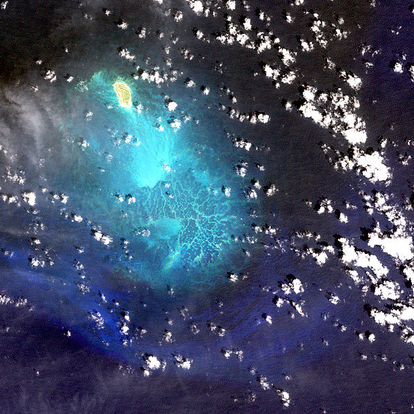
Deutsch: USGS-Landsat7-Satellitenbild der Insel Lisianski mit den südlich anschließenden Neva Shoals, Nordwestliche Hawaii-Inseln
English: Lisianski Island with Neva Shoals, Northwestern Hawaiian Islands - Satellite image from USGS' Landsat7 Satellite |
| Date | not specified |
| Source | http://www.hawaiireef.noaa.gov/imagery/rpa.html |
| Author | Landsat images were purchased by US Geological Survey |
Licensing
This image is in the
public domain in the United States because it only contains materials that originally came from the
United States Geological Survey, an agency of the
United States Department of the Interior. For more information, see
the official USGS copyright policy.
|
| This file is in the public domain in the United States because it was solely created by NASA. NASA copyright policy states that "NASA material is not protected by copyright unless noted". (See Template:PD-USGov, NASA copyright policy page or JPL Image Use Policy.) | ||
 |
Warnings:
|
File history
Click on a date/time to view the file as it appeared at that time.
| Date/Time | Thumbnail | Dimensions | User | Comment | |
|---|---|---|---|---|---|
| current | 12:28, 9 March 2007 |
| 1,050 × 1,050 (832 KB) | Telim tor | == Information == {{Information |Description= 25px Lisianki Island with Neva Shoals - Satellite image from USGS' Landsat7 Satellite 25px USGS-Landsat7-Satellitenbild der Insel Lisiansk |
File usage
The following pages on the English Wikipedia use this file (pages on other projects are not listed):
Global file usage
The following other wikis use this file:
- Usage on de.wikipedia.org
- Usage on id.wikipedia.org
- Usage on ru.wikipedia.org
- Usage on vi.wikipedia.org