Size of this preview:
800 × 577 pixels. Other resolutions:
320 × 231 pixels |
640 × 461 pixels |
1,024 × 738 pixels |
1,280 × 923 pixels |
2,560 × 1,845 pixels |
3,277 × 2,362 pixels.
Original file (3,277 × 2,362 pixels, file size: 1.39 MB, MIME type: image/png)
| This is a file from the
Wikimedia Commons. Information from its
description page there is shown below. Commons is a freely licensed media file repository. You can help. |
Summary
| Description |
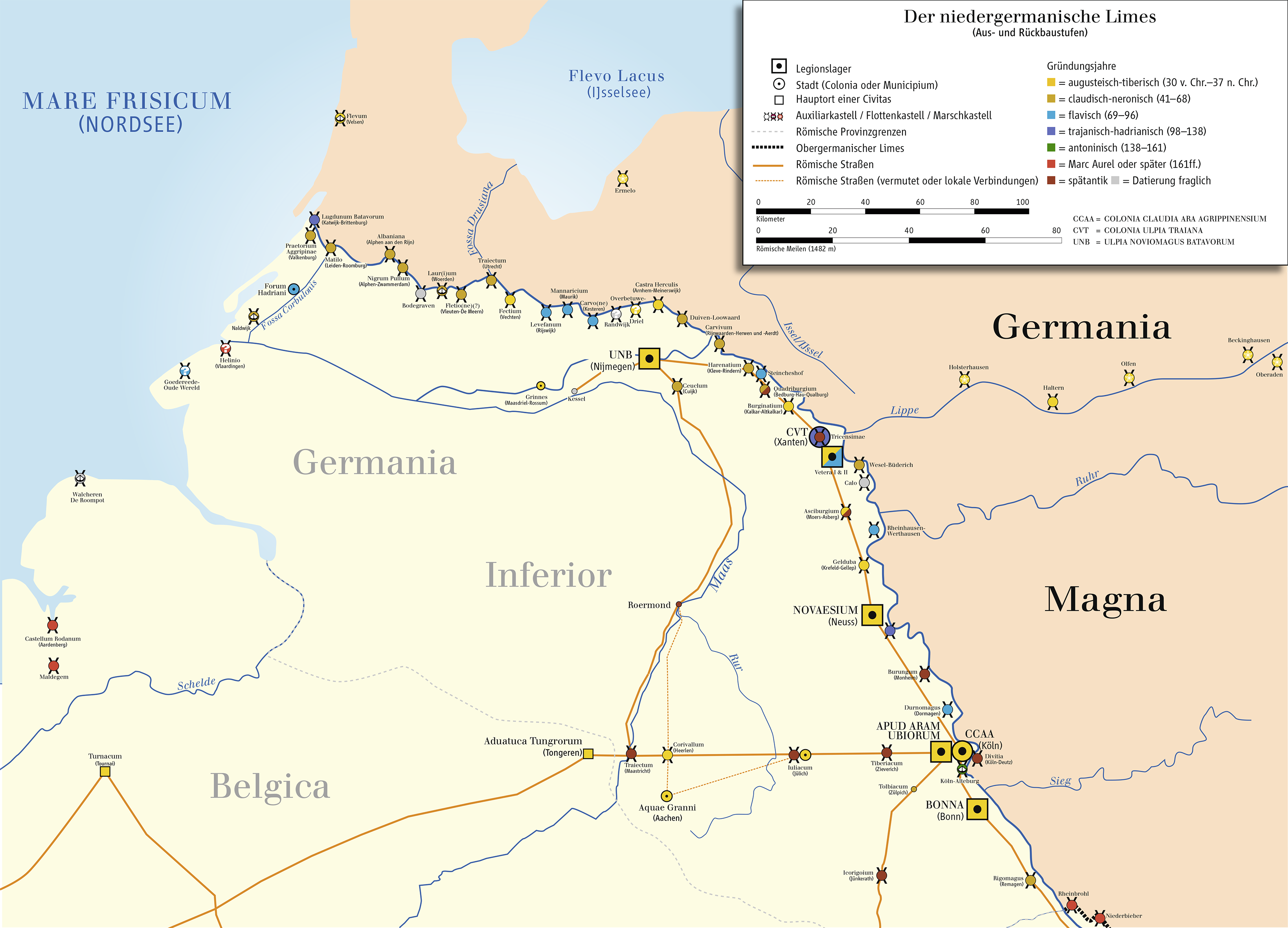
English: Map of Limes The Lower (Northern) Germanic Limes,
Deutsch: Karte des Niedergermanischen Limes |
| Date | |
| Source | Eigenes Werk (own work); Source of Information: Putzger – Historischer Weltatlas, 89. Auflage, 1965; Westermanns Großer Atlas zur Weltgeschichte, 1978; Hugo Thoen (Red.): De Romeinen langs de Vlaamse Kust. Gemeentekrediet, Koksijde en Oudenburg 1987 |
| Author | Ziegelbrenner |
| Other versions | Italian version |

|
This historical map image could be re-created using
vector graphics as an
SVG file. This has several advantages; see
Commons:Media for cleanup for more information. If an SVG form of this image is available, please upload it and afterwards replace this template with
{{
vector version available|new image name}}
.
It is recommended to name the SVG file “Limes1.svg”—then the template Vector version available (or Vva) does not need the new image name parameter. |

|
This map has been made or improved in the German
Kartenwerkstatt (Map Lab). You can
propose maps to improve as well.
|
Licensing
I, the copyright holder of this work, hereby publish it under the following licenses:

|
Permission is granted to copy, distribute and/or modify this document under the terms of the GNU Free Documentation License, Version 1.2 or any later version published by the Free Software Foundation; with no Invariant Sections, no Front-Cover Texts, and no Back-Cover Texts. A copy of the license is included in the section entitled GNU Free Documentation License. |
This file is licensed under the
Creative Commons
Attribution-Share Alike 3.0 Unported license.
- You are free:
- to share – to copy, distribute and transmit the work
- to remix – to adapt the work
- Under the following conditions:
- attribution – You must give appropriate credit, provide a link to the license, and indicate if changes were made. You may do so in any reasonable manner, but not in any way that suggests the licensor endorses you or your use.
- share alike – If you remix, transform, or build upon the material, you must distribute your contributions under the same or compatible license as the original.
You may select the license of your choice.
File history
Click on a date/time to view the file as it appeared at that time.
| Date/Time | Thumbnail | Dimensions | User | Comment | |
|---|---|---|---|---|---|
| current | 14:15, 2 August 2021 |
| 3,277 × 2,362 (1.39 MB) | Ziegelbrenner | Corrected Jülich & IJsselsee |
| 17:36, 7 January 2013 |
 | 3,277 × 2,362 (679 KB) | Ziegelbrenner | 2013-01-07 | |
| 14:56, 15 November 2012 |
 | 3,277 × 2,362 (1.11 MB) | Hawky.diddiz | Optimized | |
| 13:48, 13 October 2011 |
 | 3,277 × 2,362 (1.26 MB) | Ziegelbrenner | 2011-10-13 | |
| 15:40, 23 September 2011 |
 | 3,278 × 2,363 (1.25 MB) | Ziegelbrenner | Neuer Forschungsstand, 2 Kastelle nachgetrage, 2011-09-23 | |
| 14:23, 27 August 2010 |
 | 3,278 × 2,362 (1.8 MB) | Ziegelbrenner | 2010-08-27 | |
| 09:40, 22 September 2009 |
 | 3,277 × 2,362 (1.68 MB) | Ziegelbrenner | 2009-09-22 | |
| 10:09, 16 September 2009 |
 | 2,359 × 1,770 (1.01 MB) | Ziegelbrenner | 2009-09-16 | |
| 12:59, 3 April 2009 |
 | 2,362 × 1,790 (866 KB) | Ziegelbrenner | 2009-04-03 | |
| 08:57, 2 April 2009 |
 | 2,362 × 1,791 (792 KB) | Ziegelbrenner | 2009-04-02 |
File usage
The following pages on the English Wikipedia use this file (pages on other projects are not listed):
Global file usage
The following other wikis use this file:
- Usage on bs.wikipedia.org
- Usage on cs.wikipedia.org
- Usage on de.wikipedia.org
- 71
- Limes (Grenzwall)
- Geschichte des Ruhrgebiets
- Vetera
- Fossa Drusiana
- Asciburgium
- Novaesium
- Wikipedia:Redaktion Altertum/Römischer Limes
- Gelduba
- Niedergermanischer Limes
- Wikipedia:Redaktion Altertum/Römischer Limes/Pictothek
- Wikipedia:Redaktion Altertum/Römischer Limes/Sonstige Baustellen
- Benutzer Diskussion:Joschel
- Noordwijk
- Wikipedia Diskussion:Redaktion Altertum/Römischer Limes/Sonstige Baustellen
- Burgus Asperden
- Calo (Kastell)
- Burginatium
- Quadriburgium
- Harenatium
- Kleinkastell Werthausen
- Römerlager apud aram Ubiorum
- Carvium
- Kastell Duiven-Loowaard
- Rigomagus
- Castra Herculis
- Kastell Overbetuwe-Driel
- Kastell Overbetuwe-Randwijk
- Carvo
- Mannaricium
- Levefanum
- Kastell Steincheshof
- Römerlager Olfen
- Marschlager Ermelo
- Durnomagus
- Lugdunum Batavorum
- Portal:Rhein-Kreis Neuss
- Portal:Rhein-Kreis Neuss/Artikel des Monats
- Portal:Rhein-Kreis Neuss/Artikel des Monats/Archiv
- Benutzer:Drekamu/Baustelle/Flevum
- Benutzer:Ziegelbrenner/Meine Bilder auf Commons
- Fectio
- Gaius Minicius Italus
- Forum Hadriani
- Kastell Op de Hoge Woerd
- Albaniana
View more global usage of this file.