
Size of this PNG preview of this SVG file:
577 × 599 pixels. Other resolutions:
231 × 240 pixels |
462 × 480 pixels |
740 × 768 pixels |
986 × 1,024 pixels |
1,972 × 2,048 pixels |
755 × 784 pixels.
Original file (SVG file, nominally 755 × 784 pixels, file size: 364 KB)
| This is a file from the
Wikimedia Commons. Information from its
description page there is shown below. Commons is a freely licensed media file repository. You can help. |
Summary
| Description |
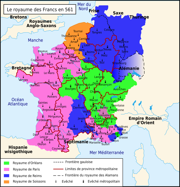
Français : Le royaume des Francs en 561. |
| Date | |
| Source | Travail personnel sur un fond de carte de historicair : Image:Blank map of Gaul 1st century BC.svg. D'après Paul Vidal de La Blache, Gaule à la mort de Clotaire (561) Image:Division of Gaul - 561.jpg, Atlas général d'histoire et de géographie (1894), Frédéric Armand, Chilpéric Ier, La Louve éditions, 2008, p. 77 et Bruno Dumézil, La reine Brunehaut, éditions Fayard, 2008, p. 536. |
| Author | Romain0 |
| Other versions | Derivative works of this file: Le royaume des Francs en 561 ru.svg |
Licensing
| I, the copyright holder of this work, release this work into the
public domain. This applies worldwide. In some countries this may not be legally possible; if so: I grant anyone the right to use this work for any purpose, without any conditions, unless such conditions are required by law. |
File history
Click on a date/time to view the file as it appeared at that time.
| Date/Time | Thumbnail | Dimensions | User | Comment | |
|---|---|---|---|---|---|
| current | 23:33, 13 May 2010 |
| 755 × 784 (364 KB) | Romain0 | Légende + hydrographie. |
| 23:10, 13 May 2010 |
 | 755 × 784 (372 KB) | Romain0 | Couleur. | |
| 09:56, 14 March 2010 |
 | 755 × 784 (372 KB) | Romain0 | Couleur. | |
| 00:08, 14 March 2010 |
 | 755 × 784 (362 KB) | Romain0 | {{Information |Description={{fr|1=Le royaume des Francs en 561.}} |Source=Travail personnel sur un fond de carte de historicair : Image:Blank map of Gaul 1st century BC.svg. D'après Paul Vidal de La Blache, ''Gaule à la mor |
File usage
The following pages on the English Wikipedia use this file (pages on other projects are not listed):
Global file usage
The following other wikis use this file:
- Usage on avk.wikipedia.org
- Usage on de.wikipedia.org
- Usage on el.wikipedia.org
- Usage on eo.wikipedia.org
- Usage on fr.wikipedia.org
- Usage on fr.wikibooks.org
- Usage on it.wikipedia.org
- Usage on lt.wikipedia.org
- Usage on mk.wikipedia.org