
Original file (1,704 × 2,248 pixels, file size: 4.35 MB, MIME type: image/jpeg)
| This is a file from the
Wikimedia Commons. Information from its
description page there is shown below. Commons is a freely licensed media file repository. You can help. |
Summary
|
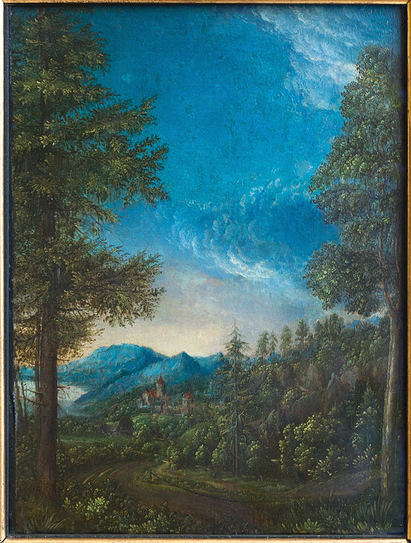
Albrecht Altdorfer:
Landscape of Danube near Regensburg
|
|||||||||||||||||||||||||||
|---|---|---|---|---|---|---|---|---|---|---|---|---|---|---|---|---|---|---|---|---|---|---|---|---|---|---|---|
| Artist |
|
 | |||||||||||||||||||||||||
| Title |
German: Donaulandschaft mit Schloss Wörth
Danube Landscape with Wörth Castle |
||||||||||||||||||||||||||
| Object type |
painting
|
||||||||||||||||||||||||||
| Genre |
landscape art
|
||||||||||||||||||||||||||
| Date | between circa 1528 and circa 1530 | ||||||||||||||||||||||||||
| Medium | color on vellum mounted on beech wood | ||||||||||||||||||||||||||
| Dimensions | height: 30.5 cm (12 in); width: 22.2 cm (8.7 in) | ||||||||||||||||||||||||||
| Collection |
|
||||||||||||||||||||||||||
| Accession number |
W.A.F.30 |
||||||||||||||||||||||||||
| Object history |
Deutsch: Das Bild kam mit der Rechbergschen Sammlung 1815 in die Sammlung Öttingen-Wallerstein, und von dort in die Alte Pinakothek nach München English: From the Rechbergschen collection in 1815, then in the Öttingen-Wallerstein collection, and bought by king Louis I of Bavaria for the Alte Pinakothek in Munich. Français : De la collection Rechbergschen en 1815, puis à la collection Öttingen-Wallerstein, puis acquis par le roi Louis Ier de Bavière pour la Alte Pinakothek de Munich. |
||||||||||||||||||||||||||
| Credit line |
lent to by Wittelsbacher Ausgleichsfond |
||||||||||||||||||||||||||
| Inscriptions |
Deutsch: Namenszeichen auf dem Baumstamm links unten. English: "Namenszeichen" on the tree trunk at the bottom left Français : "Namenszeichen" sur le tronc d'arbre en bas à gauche |
||||||||||||||||||||||||||
| Notes |
Deutsch: Die Donaulandschaft mit Schloss Wörth gehört zu den frühesten topographisch genauen Landschaftsbildern, die nicht Kulisse biblischer oder profaner Szenen, sondern autonome Darstellungen sind" (Alte Pinakothek, Sammlungskatalog, S.38)
English: According to the Alte Pinakothek catalogue, it is probably the first autonome landscape in the german painting
Français : D'après le catalogue des collections de la Alte Pinakothek, c'est probablement le plus ancien paysage "autonome" (ce n'est pas un arrière-plan d'une scène biblique ou profane) dans la peinture allemande. |
||||||||||||||||||||||||||
| References | Margit Stadlober: Der Wald in der Malerei und Graphik des Donaustils. Böhlauverlag 2006. Die Donaulandschaft bei Regensburg (richtig wäre im Strudengau) S. 264 Googlebooks | ||||||||||||||||||||||||||
| Source/Photographer | Own work, Jebulon for photograph Taken on 23 October 2013 | ||||||||||||||||||||||||||
| Permission ( Reusing this file) |
|
||||||||||||||||||||||||||
| Other versions |
 |
||||||||||||||||||||||||||


| Camera location |
| View this and other nearby images on: OpenStreetMap |
|
|---|
| This is a
retouched picture, which means that it has been digitally altered from its original version. Modifications: Frame cropped, usual level improvements. With GIMP.
|
Licensing
|
This is a faithful photographic reproduction of an original two-dimensional work of art. The work of art itself is in the public domain for the following reason:
This digital reproduction has been released under the following licenses:
In many jurisdictions, faithful reproductions of two-dimensional public domain works of art are not copyrightable. The Wikimedia Foundation's position is that these works are not copyrightable in the United States (see Commons:Reuse of PD-Art photographs). In these jurisdictions, this work is actually in the public domain and the requirements of the digital reproduction's license are not compulsory. | |||||||
This image has been assessed using the
Quality image guidelines and is considered a
Quality image.
|

|
This image has been assessed under the valued image criteria and is considered the most valued image on Commons within the scope: Donaulandschaft bei Regensburg by Albrecht Altdorfer, Alte Pinakothek, Munich.. You can see its nomination here. |
File history
Click on a date/time to view the file as it appeared at that time.
| Date/Time | Thumbnail | Dimensions | User | Comment | |
|---|---|---|---|---|---|
| current | 15:44, 10 May 2014 |
| 1,704 × 2,248 (4.35 MB) | Jebulon | User created page with UploadWizard |
File usage
Global file usage
The following other wikis use this file:
- Usage on cs.wikipedia.org
- Usage on de.wikipedia.org
- Usage on el.wikipedia.org
- Usage on fr.wikipedia.org
- Usage on ro.wikipedia.org