Original file (597 × 1,024 pixels, file size: 948 KB, MIME type: image/png)
| This is a file from the
Wikimedia Commons. Information from its
description page there is shown below. Commons is a freely licensed media file repository. You can help. |
Summary
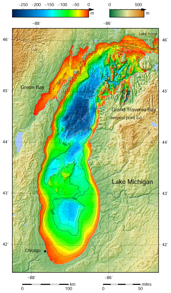
| Description |
English: Lake Michigan bathymetric shaded relief map contoured with interval 25 m (100 m with thicker lines). The deepest point is marked with "×". For land the vertical datum is sea level, for bathymetry low water datum of the lake. The map was created using the Generic Mapping Tools, GMT, version 5.1.1. |
| Date | |
| Source |
Own work using: the following Public Domain datasets (grids):
The coordinates of deepest point are taken from the NOAA Great LakesEnvironmental Research Laboratory webpage (
www.glerl.noaa.gov/, kml file Google Earth Great Lakes Tour). |
| Author | Darekk2 using the Great Lakes Bathymetry and GLOBE tiles |
| Other versions |
|

Licensing
Attribution (in addition to the author of this map):
The NGDC in it's
copyright notice says:
As required by 17 U.S.C. 403, third parties producing copyrighted works consisting predominantly of the material produced by U.S. government agencies must provide notice with such work(s) identifying the U.S. Government material incorporated and stating that such material is not subject to copyright protection within the United States. (...)
(for credits see the Source section).
and Great Lakes Bathymetry and GLOBE
(see above and the Source section)
- You are free:
- to share – to copy, distribute and transmit the work
- to remix – to adapt the work
- Under the following conditions:
- attribution – You must give appropriate credit, provide a link to the license, and indicate if changes were made. You may do so in any reasonable manner, but not in any way that suggests the licensor endorses you or your use.
- share alike – If you remix, transform, or build upon the material, you must distribute your contributions under the same or compatible license as the original.
File history
Click on a date/time to view the file as it appeared at that time.
| Date/Time | Thumbnail | Dimensions | User | Comment | |
|---|---|---|---|---|---|
| current | 12:24, 10 May 2015 |
| 597 × 1,024 (948 KB) | Darekk2 | a small island in NE |
| 16:36, 9 May 2015 |
 | 597 × 1,024 (948 KB) | Darekk2 | the lakes tiles better assembled, retouched western part of Green Bay | |
| 22:31, 9 April 2015 |
 | 597 × 1,024 (948 KB) | Darekk2 | replaced contours generated by GMT program by contours downloaded from the NOAA website; added some annotations to contours; made contours 100 and 200 m bold; added rivers and minor lakes; moved Lake Michigan label and Chicago circle | |
| 13:29, 4 April 2015 |
 | 597 × 1,024 (942 KB) | Darekk2 | User created page with UploadWizard |
File usage
Global file usage
The following other wikis use this file:
- Usage on ban.wikipedia.org
- Usage on hr.wikipedia.org
- Usage on kn.wikipedia.org
- Usage on ta.wikipedia.org
- Usage on vi.wikipedia.org
- Usage on www.wikidata.org