
Size of this preview:
800 × 500 pixels. Other resolutions:
320 × 200 pixels |
640 × 400 pixels |
1,024 × 640 pixels |
1,280 × 800 pixels |
2,560 × 1,600 pixels |
4,280 × 2,675 pixels.
Original file (4,280 × 2,675 pixels, file size: 10.28 MB, MIME type: image/jpeg)
| This is a file from the
Wikimedia Commons. Information from its
description page there is shown below. Commons is a freely licensed media file repository. You can help. |
Summary
| Description | |
| Date | Taken on 10 September 2013, 19:18:01 |
| Source | Own work |
| Author | Christian Ferrer |
| Permission ( Reusing this file) |
I, the copyright holder of this work, hereby publish it under the following license: This file is licensed under the
Creative Commons
Attribution-Share Alike 3.0 Unported license.
|
| Camera location |
| View this and other nearby images on: OpenStreetMap |
|
|---|

|
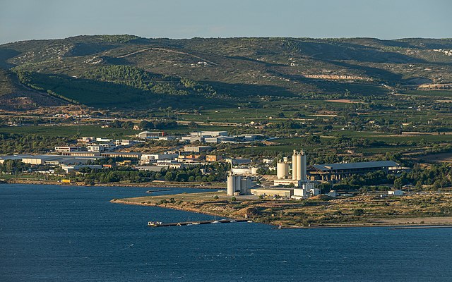
This image has been assessed under the valued image criteria and is considered the most valued image on Commons within the scope: Horizon Sud industrial park, Frontignan, Hérault, France. View from southwest in 2013.. You can see its nomination here. |
|
|
This image has been assessed under the valued image criteria and is considered the most valued image on Commons within the scope: The Lafarge cement plant in Frontignan, Hérault, France. View from southwest in 2013.. You can see its nomination here. |
This image has been assessed using the
Quality image guidelines and is considered a
Quality image.
|
File history
Click on a date/time to view the file as it appeared at that time.
| Date/Time | Thumbnail | Dimensions | User | Comment | |
|---|---|---|---|---|---|
| current | 16:44, 3 January 2014 |
| 4,280 × 2,675 (10.28 MB) | Christian Ferrer | CA |
| 15:31, 3 January 2014 |
 | 4,280 × 2,675 (10.01 MB) | Christian Ferrer | rework | |
| 17:43, 16 September 2013 |
 | 5,200 × 3,250 (14.78 MB) | Christian Ferrer | User created page with UploadWizard |
File usage
The following pages on the English Wikipedia use this file (pages on other projects are not listed):
Global file usage
The following other wikis use this file:
- Usage on fr.wikipedia.org
- Usage on nl.wikipedia.org