
Size of this preview:
800 × 208 pixels. Other resolutions:
320 × 83 pixels |
640 × 166 pixels |
1,024 × 266 pixels |
1,280 × 333 pixels |
2,560 × 665 pixels |
13,471 × 3,500 pixels.
Original file (13,471 × 3,500 pixels, file size: 4.68 MB, MIME type: image/jpeg)
| This is a file from the
Wikimedia Commons. Information from its
description page there is shown below. Commons is a freely licensed media file repository. You can help. |
_(18951635646).jpg)
Summary
| Description |
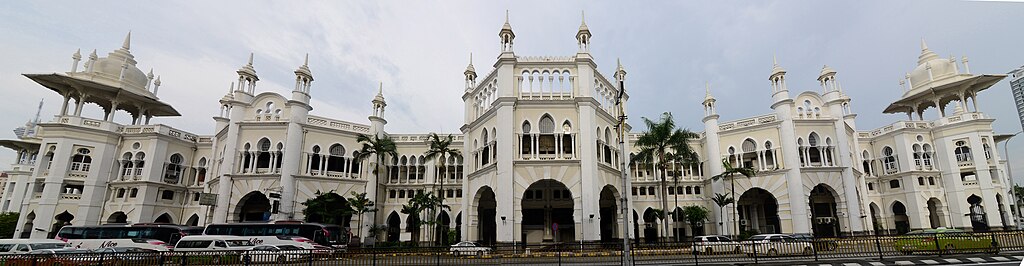
English: Kuala Lumpur Railway Station is a railway station located in Kuala Lumpur, Malaysia. Completed in 1910 to replace an older station on the same site, the station was Kuala Lumpur's railway hub in the city for the Federated Malay States Railways and Malayan Railway (Malay: Keretapi Tanah Melayu), before Kuala Lumpur Sentral assumed much of its role in 2001. The station is notable for its architecture, adopting a mixture of Eastern and Western designs.
The station is located along a road named Jalan Sultan Hishamuddin, previously known as Victory Avenue, which in turn was part of Damansara Road. The station is located closely to the similarly designed Railway Administration Building, as well as the National Mosque and Dayabumi Complex. The Pasar Seni LRT station is located 400 metres away, across the Klang River. |
| Date | |
| Source | Kuala Lumpur railway station (Photomerged panorama) |
| Author | Jorge Láscar from Melbourne, Australia |
| Camera location |
| View this and other nearby images on: OpenStreetMap |
|
|---|
_(18951635646).jpg¶ms=003.139850_N_0101.692722_E_globe:Earth_type:camera_source:Flickr_&language=en)
Licensing
This file is licensed under the
Creative Commons
Attribution 2.0 Generic license.
- You are free:
- to share – to copy, distribute and transmit the work
- to remix – to adapt the work
- Under the following conditions:
- attribution – You must give appropriate credit, provide a link to the license, and indicate if changes were made. You may do so in any reasonable manner, but not in any way that suggests the licensor endorses you or your use.
| This image was originally posted to Flickr by Jorge Lascar at https://flickr.com/photos/8721758@N06/18951635646 ( archive). It was reviewed on 2 February 2018 by FlickreviewR 2 and was confirmed to be licensed under the terms of the cc-by-2.0. |
File history
Click on a date/time to view the file as it appeared at that time.
| Date/Time | Thumbnail | Dimensions | User | Comment | |
|---|---|---|---|---|---|
| current | 10:31, 2 February 2018 |
| 13,471 × 3,500 (4.68 MB) | Thesupermat2 | Transferred from Flickr via Flickr2Commons |
File usage
No pages on the English Wikipedia use this file (pages on other projects are not listed).
Global file usage
The following other wikis use this file:
- Usage on blk.wikipedia.org
- Usage on fa.wikipedia.org
- Usage on ms.wikipedia.org
- Usage on simple.wikipedia.org
- Usage on ta.wikipedia.org
- Usage on th.wikipedia.org
_(18951635646).jpg)