Size of this preview:
782 × 600 pixels. Other resolutions:
313 × 240 pixels |
626 × 480 pixels |
1,002 × 768 pixels |
1,280 × 982 pixels |
2,560 × 1,963 pixels |
2,736 × 2,098 pixels.
Original file (2,736 × 2,098 pixels, file size: 4.83 MB, MIME type: image/jpeg)
| This is a file from the
Wikimedia Commons. Information from its
description page there is shown below. Commons is a freely licensed media file repository. You can help. |
Summary
| Description |
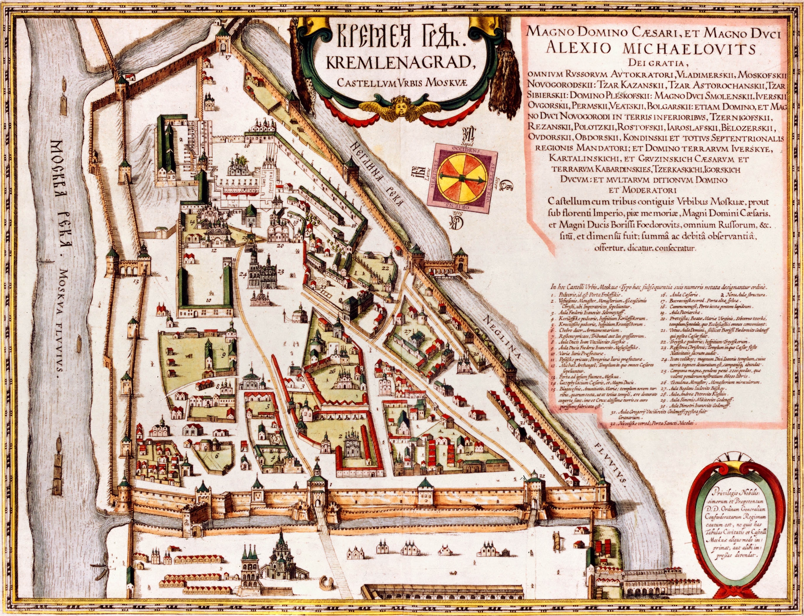
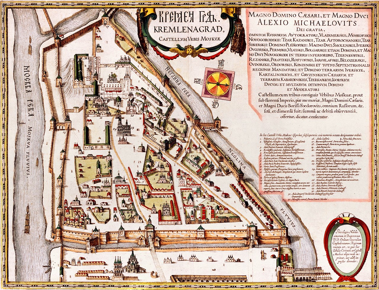
English: Kremlenagrad Castellum Urbis Moskvae: the first detailed map of the Moscow Kremlin, created during the reign of
Alexis Mikhailovich Latina: Tabula Castelli Urbi Moskuae (Kremlin); Alexio Michaelo filio rege a Ioanne Blaeuo factus |
| Date | |
| Source |
|
| Author | Joan Blaeu |
Licensing
|
This work is in the public domain in its country of origin and other countries and areas where the copyright term is the author's life plus 100 years or fewer. This work is in the public domain in the United States because it was published (or registered with the U.S. Copyright Office) before January 1, 1929. | |
| This file has been identified as being free of known restrictions under copyright law, including all related and neighboring rights. | |
| Annotations | This image is annotated: View the annotations at Commons |
File history
Click on a date/time to view the file as it appeared at that time.
| Date/Time | Thumbnail | Dimensions | User | Comment | |
|---|---|---|---|---|---|
| current | 05:05, 13 May 2008 |
| 2,736 × 2,098 (4.83 MB) | Kimse | Higher resolution from http://historic-cities.huji.ac.il/russia/moscow/maps/blaeu_french_1663_v2.html |
| 10:26, 3 September 2006 |
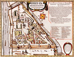
 | 350 × 307 (25 KB) | Ghirlandajo | "Kremlenagrad": the first detailed map of the Moscow Kremlin, 1601. Source: http://www.kreml.ru/ru/main/history/kremlin/XVI/ Category:Moscow Kremlin Category:History of Moscow |
File usage
The following pages on the English Wikipedia use this file (pages on other projects are not listed):
Global file usage
The following other wikis use this file:
- Usage on af.wikipedia.org
- Usage on am.wikipedia.org
- Usage on az.wikipedia.org
- Usage on bs.wikipedia.org
- Usage on cs.wikipedia.org
- Usage on da.wikipedia.org
- Usage on de.wikipedia.org
- Usage on el.wikipedia.org
- Usage on fy.wikipedia.org
- Usage on gl.wikipedia.org
- Usage on id.wikipedia.org
- Usage on ko.wikipedia.org
- Usage on la.wikipedia.org
- Usage on lld.wikipedia.org
- Usage on my.wikipedia.org
- Usage on pt.wikipedia.org
- Usage on ru.wikipedia.org
- Usage on sh.wikipedia.org
- Usage on sk.wikipedia.org
- Usage on sl.wikipedia.org
- Usage on sq.wikipedia.org
- Usage on sr.wikipedia.org
- Usage on uk.wikipedia.org
- Московський кремль
- Шаблон:Moscow-week-new
- Шаблон:Moscow-week-improve
- Обговорення:Новокур'яново
- Обговорення:Хохловський майдан
- Обговорення:Мавзолей (садиба Суханово)
- Обговорення:Доменіко Жилярді
- Обговорення:Щукін Дмитро Іванович
- Обговорення:Російський музей лісу
- Обговорення:Садиба Братцево
- Обговорення:Музей Ігоря Талькова
- Обговорення:Бахрушин Олексій Олександрович
- Обговорення:Павелецька (станція метро, Кільцева лінія)
- Обговорення:Кремлівська АЗС на Волхонці
- Обговорення:Церква Спаса, садиба Вороново
- Будівля приказів
- Іванівська площа
- Usage on ur.wikipedia.org