
Size of this preview:
800 × 498 pixels. Other resolutions:
320 × 199 pixels |
640 × 398 pixels |
1,038 × 646 pixels.
Original file (1,038 × 646 pixels, file size: 63 KB, MIME type: image/jpeg)
| This is a file from the
Wikimedia Commons. Information from its
description page there is shown below. Commons is a freely licensed media file repository. You can help. |
Summary
| Description |
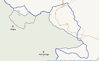
English: The map depicts of the Line of Actual Control (LAC) marked by the US Office of Geographer in 2013 (in blue) and the LAC in effect in July 2020 marked by the OpenStreetMap (in green). This map should not be used on Wikipedia without backing from published reliable sources. |
| Date | |
| Source | https://earthworks.stanford.edu/catalog/stanford-yg089df0008 |
| Author | United States Office of Geographer, Stanford University, OpenStreetMap |
Licensing
This work is in the
public domain in the United States because it is a
work prepared by an officer or employee of the United States Government as part of that person’s official duties under the terms of
Title 17, Chapter 1, Section 105 of the
US Code.
Note: This only applies to original works of the Federal Government and not to the work of any individual
U.S. state,
territory, commonwealth, county, municipality, or any other subdivision. This template also does not apply to postage stamp designs published by the
United States Postal Service
since 1978. (See §
313.6(C)(1) of Compendium of U.S. Copyright Office Practices). It also does not apply to certain US coins; see
The US Mint Terms of Use.
|
 | |
| This file has been identified as being free of known restrictions under copyright law, including all related and neighboring rights. | ||
File history
Click on a date/time to view the file as it appeared at that time.
| Date/Time | Thumbnail | Dimensions | User | Comment | |
|---|---|---|---|---|---|
| current | 23:28, 25 July 2020 |
| 1,038 × 646 (63 KB) | Kautilya3 | Uploaded a work by United States Office of Geographer, Stanford University, OpenStreetMap from https://earthworks.stanford.edu/catalog/stanford-yg089df0008 with UploadWizard |
File usage
The following pages on the English Wikipedia use this file (pages on other projects are not listed):
Global file usage
The following other wikis use this file:
- Usage on ja.wikipedia.org