
Original file (2,904 × 1,954 pixels, file size: 7.74 MB, MIME type: image/jpeg)
| This is a file from the
Wikimedia Commons. Information from its
description page there is shown below. Commons is a freely licensed media file repository. You can help. |
.jpg)
Summary
| Description |
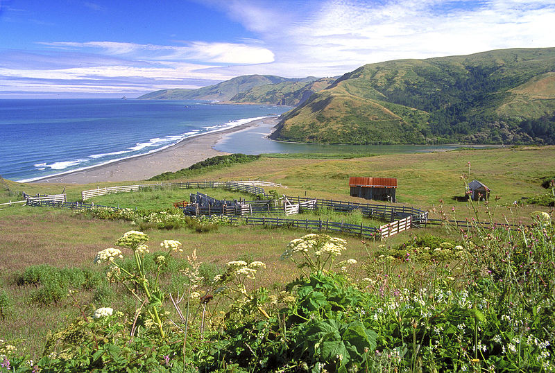
A spectacular meeting of land and sea is certainly the dominant feature of King Range National Conservation Area. Mountains seem to thrust straight out of the surf; a precipitous rise rarely surpassed on the continental U.S. coastline. King Peak, the highest point at 4,088 feet, is only three miles from the ocean. The King Range NCA covers 68,000 acres and extends along 35 miles of coastline between the mouth of the Mattole River and Sinkyone Wilderness State Park. Here the landscape was too rugged for highway building, forcing State Highway 1 and U.S. 101 inland. The remote region is known as California's Lost Coast, and is only accessed by a few back roads. The recreation opportunities here are as diverse as the landscape. The Douglas-fir peaks attract hikers, hunters, campers and mushroom collectors, while the coast beckons to surfers, anglers, beachcombers, and abalone divers to name a few. For more information visit: www.blm.gov/ca/st/en/fo/arcata/kingrange/index.html Photos/Videos: Bob Wick, BLM |
| Date | |
| Source | King Range National Conservation Area |
| Author | Bureau of Land Management |
Licensing
- You are free:
- to share – to copy, distribute and transmit the work
- to remix – to adapt the work
- Under the following conditions:
- attribution – You must give appropriate credit, provide a link to the license, and indicate if changes were made. You may do so in any reasonable manner, but not in any way that suggests the licensor endorses you or your use.
| This image was originally posted to Flickr by mypubliclands at https://flickr.com/photos/91981596@N06/18967577236. It was reviewed on 4 August 2015 by FlickreviewR and was confirmed to be licensed under the terms of the cc-by-2.0. |
| This image is a work of a
Bureau of Land Management* employee, taken or made as part of that person's official duties. As a
work of the
U.S. federal government, the image is in the
public domain in the United States. *or predecessor organization |
File history
Click on a date/time to view the file as it appeared at that time.
| Date/Time | Thumbnail | Dimensions | User | Comment | |
|---|---|---|---|---|---|
| current | 18:39, 4 August 2015 |
| 2,904 × 1,954 (7.74 MB) | Wilfredor | Transferred from Flickr via Flickr2Commons |
File usage
Global file usage
The following other wikis use this file:
- Usage on he.wikipedia.org
.jpg)