No higher resolution available.
Kilauea_Lava_Hazard_Map.gif (359 × 270 pixels, file size: 18 KB, MIME type: image/gif)
| This is a file from the
Wikimedia Commons. Information from its
description page there is shown below. Commons is a freely licensed media file repository. You can help. |
Summary
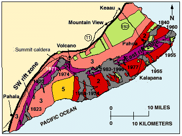
| Description |
English: Hazard zones for lava flows on Kilauea. The flows erupted since 1800 are shown in gray and dated. Twenty-eight percent of the area encompassed by Zones 1 and 2 on the east half of the volcano has been covered by lava since 1955. The major housing subdivisions on the slopes of the volcano are shown in green. |
| Date | |
| Source | http://pubs.usgs.gov/gip/hazards/kilauea.html |
| Author | USGS |
This is the work of the US Government and is in the public domain.
Licensing
This image is in the
public domain in the United States because it only contains materials that originally came from the
United States Geological Survey, an agency of the
United States Department of the Interior. For more information, see
the official USGS copyright policy.
|
File history
Click on a date/time to view the file as it appeared at that time.
| Date/Time | Thumbnail | Dimensions | User | Comment | |
|---|---|---|---|---|---|
| current | 10:08, 27 May 2010 |
| 359 × 270 (18 KB) | Infanalyst | {{Information |Description={{en|1=Hazard zones for lava flows on Kilauea. The flows erupted since 1800 are shown in gray and dated. Twenty-eight percent of the area encompassed by Zones 1 and 2 on the east half of the volcano has been covered by lava sinc |
File usage
The following pages on the English Wikipedia use this file (pages on other projects are not listed):
Global file usage
The following other wikis use this file:
- Usage on ca.wikipedia.org
- Usage on fr.wikipedia.org