
Size of this preview:
800 × 600 pixels. Other resolutions:
320 × 240 pixels |
640 × 480 pixels |
1,024 × 768 pixels.
Original file (1,024 × 768 pixels, file size: 131 KB, MIME type: image/jpeg)
| This is a file from the
Wikimedia Commons. Information from its
description page there is shown below. Commons is a freely licensed media file repository. You can help. |
Summary
| Description |
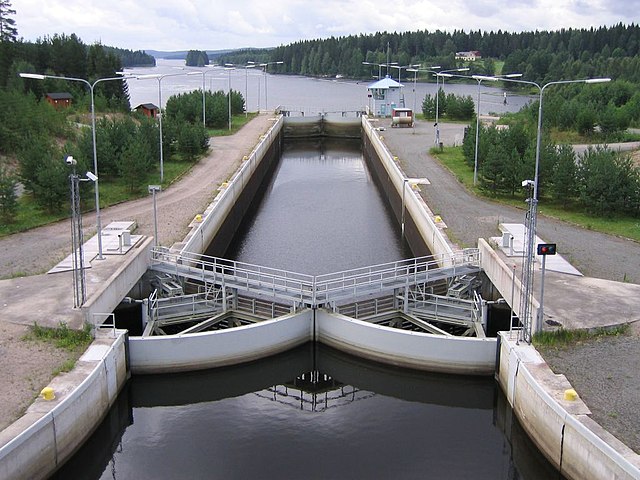
English: Kapeenkoski Lock of Keitele–Päijänne canal in Äänekoski, Finland
Suomi: Keiteleen kanavan Kapeenkosken sulku Äänekoskella |
| Date | |
| Source | Own work |
| Author | Argus fin |
| Camera location | | View this and other nearby images on: OpenStreetMap |
|
|---|
Licensing
| I, the copyright holder of this work, release this work into the
public domain. This applies worldwide. In some countries this may not be legally possible; if so: I grant anyone the right to use this work for any purpose, without any conditions, unless such conditions are required by law. |
File history
Click on a date/time to view the file as it appeared at that time.
| Date/Time | Thumbnail | Dimensions | User | Comment | |
|---|---|---|---|---|---|
| current | 15:41, 15 January 2008 |
| 1,024 × 768 (131 KB) | Argus fin | {{Information |Description= {{fi}} Keiteleen kanavan sulku {{en}} Keitele - Päijänne canal in Finland |Source=self-made |Date= June 2005 |Author= Argus fin |Permission= |other_versions= }} |
File usage
The following pages on the English Wikipedia use this file (pages on other projects are not listed):
Global file usage
The following other wikis use this file:
- Usage on arz.wikipedia.org
- Usage on avk.wikipedia.org
- Usage on ca.wikipedia.org
- Usage on da.wikipedia.org
- Usage on en.wikivoyage.org
- Usage on en.wiktionary.org
- Usage on es.wikipedia.org
- Usage on fa.wikipedia.org
- Usage on fr.wikipedia.org
- Usage on gl.wikipedia.org
- Usage on he.wikipedia.org
- Usage on hu.wikipedia.org
- Usage on io.wiktionary.org
- Usage on tr.wikipedia.org
- Usage on ur.wikipedia.org
- Usage on www.wikidata.org