
Size of this preview:
800 × 600 pixels. Other resolutions:
320 × 240 pixels |
640 × 480 pixels |
1,024 × 768 pixels |
1,280 × 960 pixels |
2,048 × 1,536 pixels.
Original file (2,048 × 1,536 pixels, file size: 724 KB, MIME type: image/jpeg)
| This is a file from the
Wikimedia Commons. Information from its
description page there is shown below. Commons is a freely licensed media file repository. You can help. |
|
This is an image of a place or building that is listed on the
National Register of Historic Places in the
United States of America. Its reference number is
84000270. |
Summary
| Description |
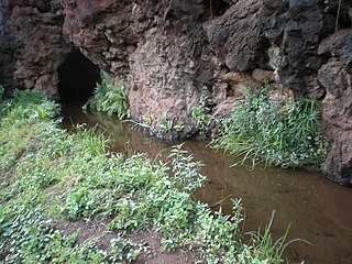
English: Menehune Ditch at tunnel, Menehune Rd., Waimea, Kauaʻi, Hawaii, on National Register of Historic Places, became Historic Landmark of the Territory of Hawaii in 1928 |
| Date | |
| Source | Own work |
| Author | Joel Bradshaw |
| Object location |
| View this and other nearby images on: OpenStreetMap |
|
|---|
Licensing
| I, the copyright holder of this work, release this work into the
public domain. This applies worldwide. In some countries this may not be legally possible; if so: I grant anyone the right to use this work for any purpose, without any conditions, unless such conditions are required by law. |
File history
Click on a date/time to view the file as it appeared at that time.
| Date/Time | Thumbnail | Dimensions | User | Comment | |
|---|---|---|---|---|---|
| current | 08:11, 30 November 2009 |
| 2,048 × 1,536 (724 KB) | Joel Bradshaw | {{Information |Description={{en|1=Menehune Ditch at tunnel, Menehune Rd., Waimea, Kaua{{okina}}i, Hawaii, on National Register of Historic Places, became Historic Landmark of the Territory of Hawaii in 1928}} |Source={{own}} |Author=[[User:Joel Bradshaw|J |
File usage
The following pages on the English Wikipedia use this file (pages on other projects are not listed):
Global file usage
The following other wikis use this file:
- Usage on arz.wikipedia.org
- Usage on www.wikidata.org