
Size of this preview:
553 × 599 pixels. Other resolutions:
221 × 240 pixels |
600 × 650 pixels.
Original file (600 × 650 pixels, file size: 466 KB, MIME type: image/png)
| This is a file from the
Wikimedia Commons. Information from its
description page there is shown below. Commons is a freely licensed media file repository. You can help. |
Summary
| Description |
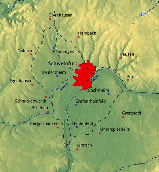
Deutsch: Topografische Karte des
Schweinfurter Beckens. Umliegende Orte sind mit rot markiert, Ortschaften innerhalb mit einem blauen Punkt. Die rote Fläche repräsentiert grob das Stadtgebiet
Schweinfurt.
English: Topografic map of the geomorphological valley "
Schweinfurter Becken". Surrounding villages are marked in red; villages inside with a blue dot. The red area roughly represents the urban area of
Schweinfurt. |
| Date | |
| Source | Own work. The image background was taken from maps-for-free.com and is released under CC0. SRTM data was used for the relief, VMAP Level 0 for the waterways and urban area. |
| Author | Michael Bemmerl |
Licensing
I, the copyright holder of this work, hereby publish it under the following license:
| This file is made available under the Creative Commons CC0 1.0 Universal Public Domain Dedication. | |
| The person who associated a work with this deed has dedicated the work to the
public domain by waiving all of their rights to the work worldwide under copyright law, including all related and neighboring rights, to the extent allowed by law. You can copy, modify, distribute and perform the work, even for commercial purposes, all without asking permission.
|
File history
Click on a date/time to view the file as it appeared at that time.
| Date/Time | Thumbnail | Dimensions | User | Comment | |
|---|---|---|---|---|---|
| current | 20:12, 23 July 2018 |
| 600 × 650 (466 KB) | NordNordWest | naming "Schweinfurt" |
| 23:51, 30 March 2018 |
 | 600 × 650 (514 KB) | WikiMichi | == {{int:filedesc}} == {{Information |description={{de|Topografische Karte des Schweinfurter Beckens. Umliegende Orte sind mit rot markiert, Ortschaften innerhalb mit einem blauen Punkt. Die rote Fläche repräsentiert grob das Stadtgebiet de:Schweinfurt (Stadtteile südlich des Mains fehlen).}} {{en|Topografic map of the geomorphological valley " Schweinfurter Becken". Surrounding villages are marked in red; villages inside with a b... |
File usage
The following pages on the English Wikipedia use this file (pages on other projects are not listed):
Global file usage
The following other wikis use this file: