
Size of this preview:
567 × 600 pixels. Other resolutions:
227 × 240 pixels |
454 × 480 pixels |
726 × 768 pixels |
968 × 1,024 pixels |
1,936 × 2,048 pixels |
2,844 × 3,008 pixels.
Original file (2,844 × 3,008 pixels, file size: 13.67 MB, MIME type: image/png)
| This is a file from the
Wikimedia Commons. Information from its
description page there is shown below. Commons is a freely licensed media file repository. You can help. |

| Description |
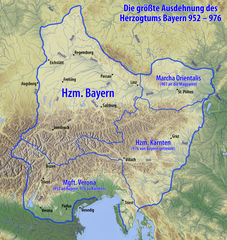
Deutsch: Karte des Herzogtums Bayern im 10. Jahrhundert |
| Date | see file history |
| Source |
Own work, using
|
| Author | Maximilian Dörrbecker ( Chumwa) |
| Permission ( Reusing this file) |
I, the copyright holder of this work, hereby publish it under the following license: This file is licensed under the
Creative Commons
Attribution-Share Alike 3.0 Unported license.
Sie dürfen das Bild zu den folgenden Bedingungen nutzen:
|
| Other versions |
|


|
This image could be re-created using
vector graphics as an
SVG file. This has several advantages; see
Commons:Media for cleanup for more information. If an SVG form of this image is available, please upload it and afterwards replace this template with
{{
vector version available|new image name}}
.
It is recommended to name the SVG file “Karte Herzogtum Bayern im 10. Jahrhundert.svg”—then the template Vector version available (or Vva) does not need the new image name parameter. |

|
This map has been made or improved in the German
Kartenwerkstatt (Map Lab). You can
propose maps to improve as well.
|
File history
Click on a date/time to view the file as it appeared at that time.
| Date/Time | Thumbnail | Dimensions | User | Comment | |
|---|---|---|---|---|---|
| current | 07:53, 13 June 2020 |
| 2,844 × 3,008 (13.67 MB) | Chumwa | corr |
| 04:14, 10 June 2015 |
 | 2,844 × 3,008 (13.67 MB) | Chumwa | ||
| 07:31, 6 June 2015 |
 | 2,844 × 3,008 (13.66 MB) | Chumwa | Hervorhebung andersherum | |
| 07:19, 6 June 2015 |
 | 2,844 × 3,008 (13.07 MB) | Chumwa | {{Information |Description= {{de|Karte des Herzogtums Bayern im 10. Jahrhundert}} |Source={{Own}}, using * information from this map by {{U|Electionworld}} * map data from [http://www.maps-for-free.com/ maps-for-free.com]... |
File usage
The following pages on the English Wikipedia use this file (pages on other projects are not listed):
Global file usage
The following other wikis use this file:
- Usage on arz.wikipedia.org
- Usage on ast.wikipedia.org
- Usage on azb.wikipedia.org
- Usage on az.wikipedia.org
- Usage on ba.wikipedia.org
- Usage on be.wikipedia.org
- Usage on bg.wikipedia.org
- Usage on bs.wikipedia.org
- Usage on ca.wikipedia.org
- Usage on cs.wikipedia.org
- Usage on da.wikipedia.org
- Usage on de.wikipedia.org
- Niederösterreich
- Geschichte Österreichs
- Arnulf I. (Bayern)
- Geschichte Wiens
- Geschichte Bayerns
- Altbayern
- Luitpoldinger
- Rohrbach in Oberösterreich
- Eberhard (Bayern)
- Wikipedia:Auskunft/Archiv/2005/November/1
- Geschichte Niederösterreichs
- Diskussion:Otto II. (HRR)
- Altbairisch
- Geschichte Oberösterreichs
- Geschichte der Stadt Perg
- Pietro IV. Candiano
- Machland
- Stammesherzogtum Baiern
- Benutzer:Jomajoma/BaustelleRB
- Wikipedia:Kartenwerkstatt/Archiv/2015-06
- Wikipedia Diskussion:Vandalismusmeldung/Archiv/2015/12
- Benutzer:Lou.gruber/Stammesherzogtum Baiern
- Wikipedia:Café/Archiv 2023 01
- Usage on de.wikiversity.org
- Usage on el.wikipedia.org
View more global usage of this file.