
Size of this preview:
495 × 599 pixels. Other resolutions:
198 × 240 pixels |
397 × 480 pixels |
838 × 1,014 pixels.
Original file (838 × 1,014 pixels, file size: 185 KB, MIME type: image/jpeg)
| This is a file from the
Wikimedia Commons. Information from its
description page there is shown below. Commons is a freely licensed media file repository. You can help. |
Summary
| Iron age strap union | |||
|---|---|---|---|
| Photographer |
Suffolk County Council, Ciorstaidh Hayward Trevarthen, 2003-11-05 10:35:02 |
||
| Title |
Iron age strap union |
||
| Description |
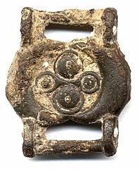
English: Copper alloy double-sided strap union. The oval central plate element has a frame of two raised crescents forming a central circular recess. On one side in the recess are two large raised ring and dot/ roundel decorations flanking two smaller ring and dots with a continuous frame forming an hourglass shape. At the centre of each of the roundels on the first side is a slight projection. This design is mirrored on the other side, although it is obscured by heavy corrosion. Instead of the domed roundels, on the second side these elements are flatter and each have a central spike that would have held a disc of coral (now missing). At either side of the oval central plate longitudinally is a circular sectioned attachment bar. These are attached on round-ended lugs projecting from the sides of the plate. These lugs are decorated with a white dot on the outer face. This is may be enamel. The strap union is quite thickly cast with a figure of eight profile. |
||
| Depicted place | (County of findspot) Dorset | ||
| Date | IRON AGE | ||
| Accession number |
FindID: 53821 Old ref: SOMDOR-CF0B77 Filename: STRAPUNIONf.JPG |
||
| Credit line |
|
||
| Source |
https://finds.org.uk/database/ajax/download/id/12020 Catalog: https://finds.org.uk/database/images/image/id/12020/recordtype/artefacts archive copy at the Wayback Machine Artefact: https://finds.org.uk/database/artefacts/record/id/53821 |
||
| Permission ( Reusing this file) |
Attribution-ShareAlike License version 4.0 (verified 23 November 2020) | ||
| Other versions |
|
||
.jpg)
| Object location |
| View this and other nearby images on: OpenStreetMap |
|
|---|
.jpg¶ms=050.723200_N_-002.644660_E_globe:Earth_class:object_type:object__&language=en)
Licensing
This file is licensed under the
Creative Commons
Attribution-Share Alike 4.0 International license.
Attribution: The Portable Antiquities Scheme/ The Trustees of the British Museum
- You are free:
- to share – to copy, distribute and transmit the work
- to remix – to adapt the work
- Under the following conditions:
- attribution – You must give appropriate credit, provide a link to the license, and indicate if changes were made. You may do so in any reasonable manner, but not in any way that suggests the licensor endorses you or your use.
- share alike – If you remix, transform, or build upon the material, you must distribute your contributions under the same or compatible license as the original.
File history
Click on a date/time to view the file as it appeared at that time.
| Date/Time | Thumbnail | Dimensions | User | Comment | |
|---|---|---|---|---|---|
| current | 16:24, 30 January 2017 |
| 838 × 1,014 (185 KB) | Fæ | Portable Antiquities Scheme, DOR, FindID: 53821, iron age, page 602, batch count 10500 |
File usage
The following pages on the English Wikipedia use this file (pages on other projects are not listed):
Global file usage
The following other wikis use this file:
- Usage on ca.wikipedia.org
- Usage on es.wikipedia.org
- Usage on vi.wikipedia.org
- Usage on www.wikidata.org
.jpg)