
Size of this preview:
800 × 397 pixels. Other resolutions:
320 × 159 pixels |
640 × 317 pixels |
1,228 × 609 pixels.
Original file (1,228 × 609 pixels, file size: 1.06 MB, MIME type: image/png)
| This is a file from the
Wikimedia Commons. Information from its
description page there is shown below. Commons is a freely licensed media file repository. You can help. |
Summary
| Description |
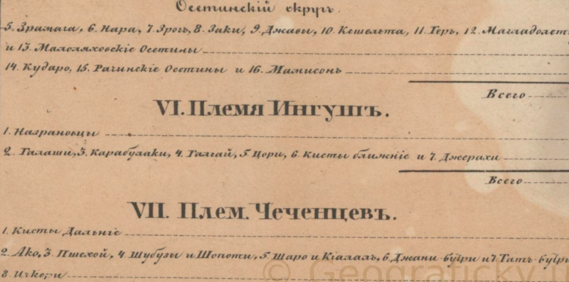
Русский: Фрагмент карты кавказского края 1842 года показывающий общества входящие в состав ингушей |
| Date | |
| Source | "Карта Кавказскаго Края: Составлена и Литографирована въ ¹/840 000 настоящей величины при Генеральномъ Штабе Отдельнаго Кавказскаго Корпуса въ 1842-го года" (in ru). |
| Author | Not specified |
Licensing
|
This work is in the public domain in its country of origin and other countries and areas where the copyright term is the author's life plus 70 years or fewer. This work is in the public domain in the United States because it was published (or registered with the U.S. Copyright Office) before January 1, 1929. | |
| This file has been identified as being free of known restrictions under copyright law, including all related and neighboring rights. | |
File history
Click on a date/time to view the file as it appeared at that time.
| Date/Time | Thumbnail | Dimensions | User | Comment | |
|---|---|---|---|---|---|
| current | 19:22, 27 March 2023 |
| 1,228 × 609 (1.06 MB) | WikiEditor1234567123 | Uploaded a work by Not specified from Карта Кавказского края 1842 года with UploadWizard |
File usage
The following pages on the English Wikipedia use this file (pages on other projects are not listed):
Global file usage
The following other wikis use this file:
- Usage on ru.wikipedia.org