
Size of this preview:
800 × 500 pixels. Other resolutions:
320 × 200 pixels |
640 × 400 pixels |
1,024 × 640 pixels |
1,280 × 800 pixels |
2,560 × 1,600 pixels |
17,280 × 10,800 pixels.
Original file (17,280 × 10,800 pixels, file size: 24.71 MB, MIME type: image/jpeg)
| This is a file from the
Wikimedia Commons. Information from its
description page there is shown below. Commons is a freely licensed media file repository. You can help. |
Summary
| Warning | The original file is very high-resolution. It might not load properly or could cause your browser to freeze when opened at full size. |
|---|
| Description |
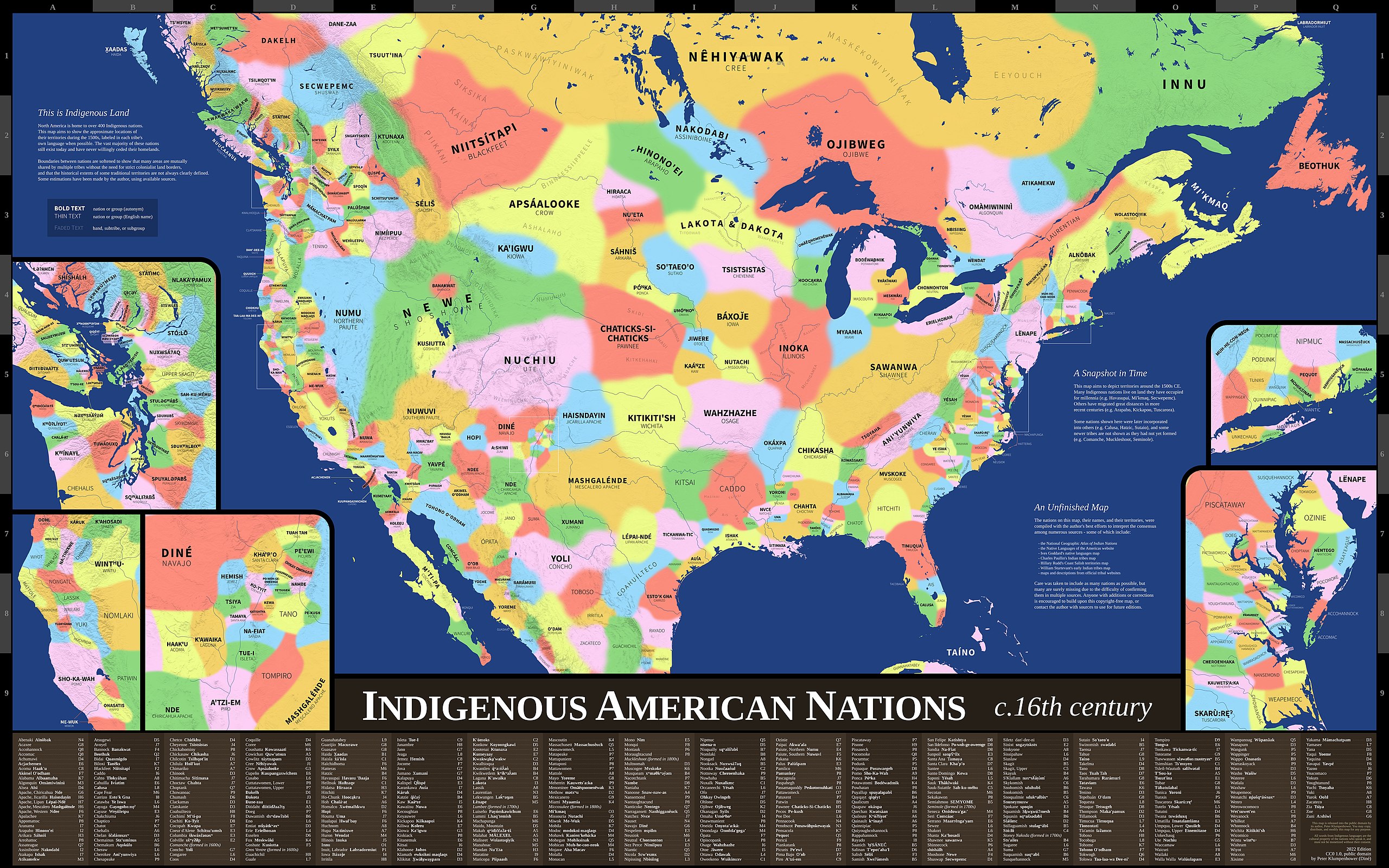
English: Map showing the approximate locations of the indigenous nations in what is now the United States during the 1500s. Nations are labeled in each tribe's own language when possible. Map uses Mercator projection. |
| Date | |
| Source | Indigenous America Maps |
| Author | Peter Klumpenhower |
| Permission ( Reusing this file) |
"This map is released into the public domain by its author, Peter Klumpenhower. You may copy, distribute, and modify this map for any purpose… CC0 1.0, public domain" (See lower right corner of map.) |
Licensing
| This file is made available under the Creative Commons CC0 1.0 Universal Public Domain Dedication. | |
| The person who associated a work with this deed has dedicated the work to the
public domain by waiving all of their rights to the work worldwide under copyright law, including all related and neighboring rights, to the extent allowed by law. You can copy, modify, distribute and perform the work, even for commercial purposes, all without asking permission.
|
File history
Click on a date/time to view the file as it appeared at that time.
| Date/Time | Thumbnail | Dimensions | User | Comment | |
|---|---|---|---|---|---|
| current | 20:07, 20 March 2022 |
| 17,280 × 10,800 (24.71 MB) | Nosferattus | Uploaded a work by Peter Klumpenhower from [https://indigamerica.blogspot.com/p/downloads.html Indigenous America Maps] with UploadWizard |
File usage
The following pages on the English Wikipedia use this file (pages on other projects are not listed):
Global file usage
The following other wikis use this file:
- Usage on be.wikipedia.org
- Usage on en.wikiquote.org
- Usage on zh.wikipedia.org