
Size of this preview:
390 × 599 pixels. Other resolutions:
156 × 240 pixels |
312 × 480 pixels |
781 × 1,200 pixels.
Original file (781 × 1,200 pixels, file size: 223 KB, MIME type: image/jpeg)
| This is a file from the
Wikimedia Commons. Information from its
description page there is shown below. Commons is a freely licensed media file repository. You can help. |
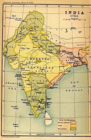
| Description | Map of India in 1765 from Imperial Gazetteer of India, volume 26, Atlas, Oxford University Press, 1908. Scanned from personal copy and uploaded by Fowler&fowler «Talk» 02:53, 25 February 2009 (UTC) | ||||
| Date | |||||
| Source | Imperial Gazetteer of India, volume 26, Atlas, Oxford University Press, 1908 | ||||
| Author | J. G. Bartholomew and Sons. Edinburgh | ||||
| Permission ( Reusing this file) |
|
||||
| Other versions |

.jpg)
File history
Click on a date/time to view the file as it appeared at that time.
| Date/Time | Thumbnail | Dimensions | User | Comment | |
|---|---|---|---|---|---|
| current | 00:09, 2 March 2011 |
| 781 × 1,200 (223 KB) | MALLUS | {{Information |Description=Map of India in 1765 from Imperial Gazetteer of India, volume 26, Atlas, Oxford University Press, 1908. Scanned from personal copy and uploaded by <font color="#B8860B">Fowler&fowler</font>[[User |
File usage
The following file is a duplicate of this file ( more details):
The following pages on the English Wikipedia use this file (pages on other projects are not listed):
Global file usage
The following other wikis use this file:
- Usage on ar.wikipedia.org
- Usage on azb.wikipedia.org
- Usage on bn.wikipedia.org
- Usage on ca.wikipedia.org
- Usage on cs.wikipedia.org
- Usage on es.wikipedia.org
- Usage on fr.wikipedia.org
- Usage on hi.wikipedia.org
- Usage on hr.wikipedia.org
- Usage on it.wikipedia.org
- Usage on ja.wikipedia.org
- Usage on mr.wikipedia.org
- Usage on ne.wikipedia.org
- Usage on or.wikipedia.org
- Usage on pa.wikipedia.org
- Usage on pnb.wikipedia.org
- Usage on pt.wikipedia.org
- Usage on ru.wikipedia.org
- Usage on ta.wikipedia.org
- Usage on te.wikipedia.org
- Usage on tr.wikipedia.org
- Usage on ur.wikipedia.org
- Usage on www.wikidata.org