Size of this preview:
800 × 512 pixels. Other resolutions:
320 × 205 pixels |
640 × 409 pixels |
1,113 × 712 pixels.
Original file (1,113 × 712 pixels, file size: 47 KB, MIME type: image/png)
| This is a file from the
Wikimedia Commons. Information from its
description page there is shown below. Commons is a freely licensed media file repository. You can help. |
| Description | |
| Source | Own work |
| Author | Omar-Toons |
| Permission ( Reusing this file) |
This file is licensed under the
Creative Commons
Attribution 1.0 Generic license.
|
| Other versions |
|
.gif)
File history
Click on a date/time to view the file as it appeared at that time.
| Date/Time | Thumbnail | Dimensions | User | Comment | |
|---|---|---|---|---|---|
| current | 21:36, 17 October 2014 |
| 1,113 × 712 (47 KB) | Omar-toons | min. ch. |
| 16:20, 2 October 2014 |
 | 1,113 × 712 (47 KB) | Omar-toons | Reverted to version as of 16:44, 25 December 2011 | |
| 23:18, 9 July 2014 |
 | 3,006 × 1,949 (500 KB) | Nastoshka | New map, extracted from the svg version. | |
| 16:44, 25 December 2011 |
 | 1,113 × 712 (47 KB) | Omar-Toons | col. + crop | |
| 03:23, 26 August 2011 |
 | 1,276 × 854 (54 KB) | Omar-Toons | last reference added (acc. to) | |
| 13:12, 18 May 2010 |
 | 1,276 × 854 (54 KB) | Omar-Toons | missed "e" 's | |
| 13:10, 18 May 2010 |
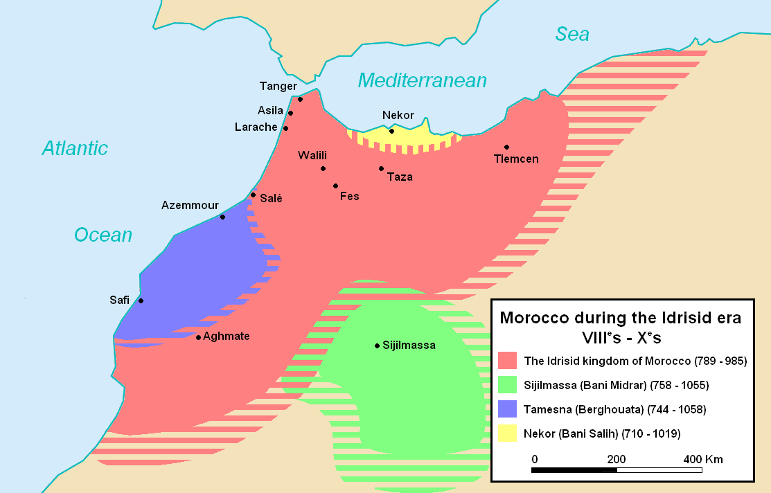
 | 1,276 × 854 (54 KB) | Omar-Toons | {{Information |Description={{en|1=Map of Morocco during the idrissid era. Refs: Euratlas maps [http://www.euratlas.net/history/europe/800/fr_800_sud-ouest.html][http://www.euratlas.net/history/europe/900/fr_900_sud-ouest.html] and Shepherd's works [http |
File usage
The following pages on the English Wikipedia use this file (pages on other projects are not listed):
Global file usage
The following other wikis use this file:
- Usage on an.wikipedia.org
- Usage on ar.wikipedia.org
- Usage on arz.wikipedia.org
- Usage on ast.wikipedia.org
- Usage on az.wikipedia.org
- Usage on ba.wikipedia.org
- Usage on bn.wikipedia.org
- Usage on bs.wikipedia.org
- Usage on ca.wikipedia.org
- Usage on cs.wikipedia.org
- Usage on de.wikipedia.org
- Usage on el.wikipedia.org
- Usage on et.wikipedia.org
- Usage on eu.wikipedia.org
- Usage on fa.wikipedia.org
- Usage on fi.wikipedia.org
- Usage on hr.wikipedia.org
- Usage on hu.wikipedia.org
- Usage on id.wikipedia.org
- Usage on it.wikipedia.org
- Usage on ja.wikipedia.org
- Usage on ka.wikipedia.org
- Usage on ko.wikipedia.org
- Usage on ml.wikipedia.org
- Usage on mt.wikipedia.org
- Usage on my.wikipedia.org
- Usage on nl.wikipedia.org
- Usage on no.wikipedia.org
- Usage on pnb.wikipedia.org
- Usage on ru.wikipedia.org
View more global usage of this file.